
Purchases made through links earn us a small commission, at no extra cost to you.
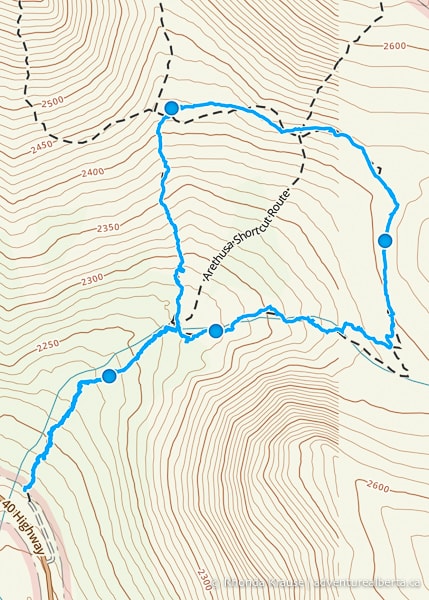
Arethusa Cirque Trail in Kananaskis Country is a scenic loop framed by impressive rocky mountains, including its namesake Mount Arethusa. During the Arethusa Cirque hike, you’ll first get to visit a beautiful meadow, then overlook a valley full of larch trees from higher ground.
.jpg)
The full Arethusa Cirque route crosses the meadow then proceeds to higher elevation where you will traverse a scree covered slope along the edge of the cirque. For those who want a short, easier hike, you can skip the loop and just do the out and back trail to the meadow (will be just shy of 1 km).
.jpg)
Arethusa Cirque Hike
Distance: 4.5 km round trip
Difficulty: Moderate
Elevation Gain: 250 m
Surface: Packed dirt, scree
Trail Type: Loop
Time: 2- 3 hours
Trailhead: East side of Highway 40 about 1.4 km southeast of the Highwood Meadows Day Use Area at Highwood Pass. Trailhead is unmarked.
Arethusa Cirque Trail Description
The Arethusa Cirque hike begins from an informal parking lot beside Highway 40. There is no signage marking the parking lot or the trailhead, since the Arethusa Cirque hike is on an unofficial trail that Alberta Parks doesn’t maintain or promote.
.jpg)
Arethusa Cirque Trail departs from the north end of the parking lot (the far side opposite where you drove in) and immediately enters into the forest.
.jpg)
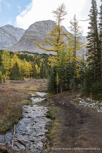
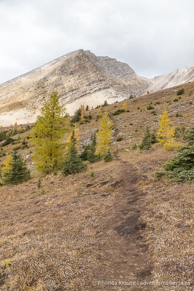
The trail makes a gentle ascent and soon larch trees start coming into view.
.jpg)
A short distance later the trail reaches the edge of the forest where there’s a stream leading towards the meadow.
Here at the end of the meadow, there’s a trail junction giving you the option to go clockwise or counterclockwise around the loop. There’s also a trail on the north side of the meadow that cuts right through the middle of the loop. On maps this path is labelled as the “Arethusa Cirque Shortcut Route” and provides a way to hike a smaller loop.
.jpg)
As for which direction to hike the Arethusa Cirque route, both ways are beautiful. If you keep left at the fork to go clockwise you’ll be ascending a steep hill, but if you keep right and go counterclockwise you’ll be descending that steep hill during the last half of the hike.
Going counterclockwise, follow the trail along the south edge of the tree-framed meadow. There are some wonderful mountain views in almost every direction and you may even catch some nice reflections in the small pond.
.jpg)
.jpg)
Keeping straight, you’ll pass alongside some larch trees as the trail leads towards the mountains.
.jpg)
At the end of the meadow you’ll reach a large pile of loose rock that has broken off the mountainside. Keep on the trail as it proceeds between the boulder pile and the stream.
.jpg)
.jpg)
Soon you’ll come to what looks like a dead end because the rock pile is now touching/partially covering the stream. Instead of going straight and boulder hopping, look for a dirt path to your left that goes into the trees. To get on that path, cross the narrow stream by using the rocks as stepping stones.
.jpg)
.jpg)
On the other side of the stream, the trail briefly zigzags through the trees before once again crossing the water to return to the side closest to the rock pile.
.jpg)
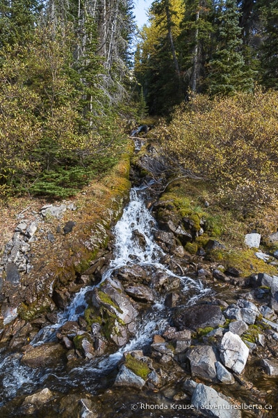
Now you’ll need to make your way along the bottom of the boulder-covered slope (there’s a vague path to follow). Keep watch for a small waterfall in the forest to your left.
.jpg)
As the trail climbs, make sure you stop every so often to look behind you because there are nice views now that you’ve gained some elevation.
.jpg)
.jpg)
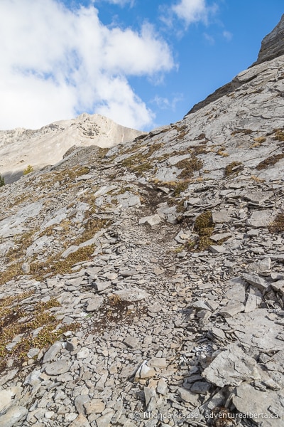
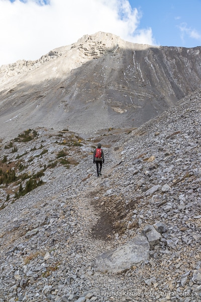
Further ahead the trail moves away from the boulders and starts climbing up a hill covered with scree. This will take you a little bit off track of what hiking apps show as the trail, but that’s okay because this is the more frequented route.
.jpg)
Keep on the well-trodden trail as it goes north up the hill, then turn right to continue straight towards the mountain. There will be wonderful views of peaks all around as well as the forested valley you are ascending from.
.jpg)
.jpg)
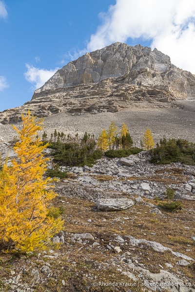
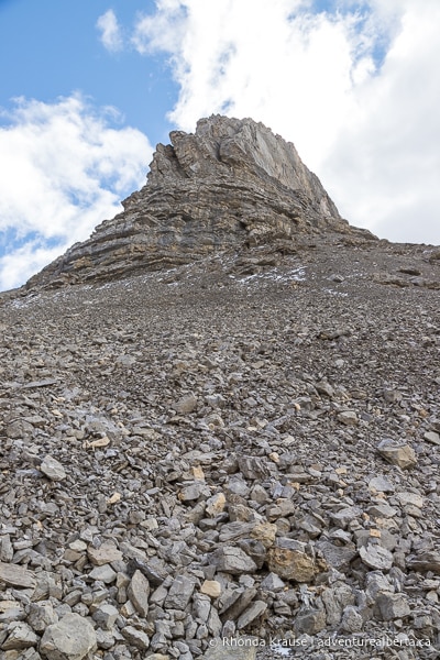
As you get closer to the east side of the cirque, the trail disappears so there’s not a clear route to follow. Basically you need to walk towards the bowl in front of Storm Mountain, then turn left to go uphill towards the scree-covered slope below the towering peak.
.jpg)
Keep watch for a more distinct path, but make sure you don’t take one that puts you at or below the treeline. Once you find your way onto the scree, there’s a clear trail to follow across the slope at the edge of the cirque.
.jpg)
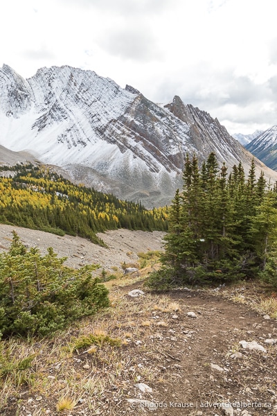
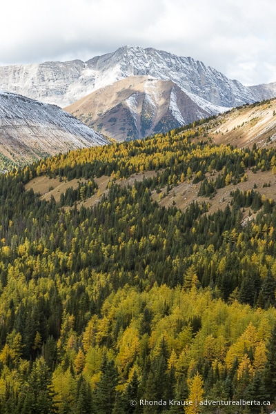
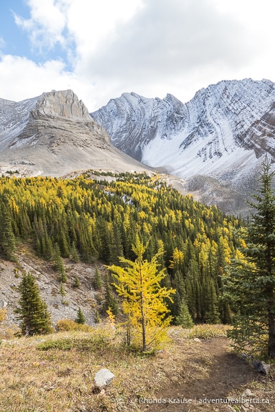
From this rocky path along the border of the cirque there are stunning views of the surrounding peaks, including Mount Arethusa and Little Arethusa, as well as Highwood Ridge. You can also look out over the tree-filled valley below, which is extra beautiful in autumn when the larch trees have turned golden yellow.
.jpg)
.jpg)
.jpg)
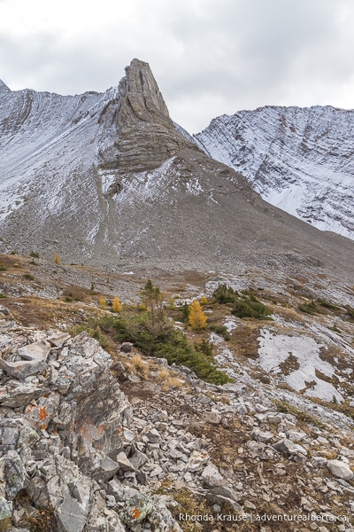
Keep walking across the slope until you come to the north end of the cirque. The trail turns left and proceeds through an almost barren patch of land below Mount Arethusa.
.jpg)
.jpg)
As you hike along the rolling, rocky landscape at the end of the cirque, you’ll get some great views of Highwood Ridge across the valley to your left, Little Arethusa straight ahead, and Mount Arethusa to your right. The mountains behind you have some interesting features too.
.jpg)
.jpg)
.jpg)
Next up the trail crosses a field of loose rock near the midpoint of the cirque. On the other side of the rock you’ll be back on grass for easier walking.
.jpg)
.jpg)
Continuing along the north end of the cirque, the trail passes by some small larch trees as you get closer to Little Arethusa. There are still marvellous mountain views in every direction.
.jpg)
.jpg)
At the northwest corner of the cirque you’ll come to a trail junction. Keeping straight will take you up to Little Arethusa peak and turning left will take you downhill along the west side of Arethusa Cirque. Go left to complete the Arethusa Cirque route.
.jpg)
During this next section of the Arethusa Cirque hike you’ll be making a steep descent between a gully and the edge of the forest. As you make your way downhill you can see the areas you hiked earlier along the south and east sides of the cirque.
.jpg)
.jpg)
Eventually the trail enters into the forest and becomes less steep as it continues to descend towards the meadow.
.jpg)
Once you arrive back at the meadow, that completes the loop of the Arethusa Cirque route. If you want, spend some time relaxing in this picturesque spot before continuing downhill on the forested trail you hiked in on to return to the parking area.
.jpg)
Review of the Arethusa Cirque Hike
Arethusa Cirque Trail is one of the top larch hikes in Kananaskis, but it also would be rewarding at other times of the year thanks to the panoramic views. You may even see some mountain sheep while hiking around the cirque.
.jpg)
A nice thing about this hike is that there are options- you can do a quick jaunt to the meadow, shorten the loop by taking the shortcut trail, or do the full Arethusa Cirque route. No matter what you choose, you will get to experience the beautiful scenery of Arethusa Cirque.
.jpg)
Since this is an unofficial trail, it’s not maintained or marked with signs. For the most part, an easy to follow trail has been established by other hikers. However, there are a few points where basic route finding might be needed (the transition from the south to the east side of the cirque comes to mind), and some people have reported going up the shortcut route by accident.
.jpg)
Pictures of the Arethusa Cirque Route
Here are some more photos of the Arethusa Cirque hike.
.jpg)
.jpg)
.jpg)
.jpg)
.jpg)
.jpg)
.jpg)
.jpg)
.jpg)
.jpg)
.jpg)
.jpg)
.jpg)
.jpg)
.jpg)
.jpg)
.jpg)
.jpg)
.jpg)
.jpg)
.jpg)
.jpg)
.jpg)
Tips for Hiking Arethusa Cirque Trail
Location: Arethusa Cirque is located in Peter Lougheed Provincial Park in Kananaskis Country. The trailhead is a short distance southeast of the Highwood Meadows Day Use Area/Highwood Pass parking lot, on the east side of Highway 40.
Getting to the Arethusa Cirque Trailhead: From Highway 1, turn south onto Highway 40 (Kananaskis Trail). Follow it past the Highwood Meadows Day Use Area at Highwood Pass and continue about 1.4 km until you see a dirt trail and informal parking area on the left hand side next to the road. The turn off is not marked.
- Highway 40 is closed south of the Kananaskis Lakes Trail junction from December 1 to June 15.
Best Time to Hike Arethusa Cirque Trail: Arethusa Cirque can only be accessed from June 15- December 1 due to a seasonal closure of the stretch of highway that goes to the trailhead. July through September is the best time to hike Arethusa Cirque Trail, but it’s especially beautiful during the last two weeks of September when the larch needles turn yellow.
- It’s not recommended to hike this trail when wet/muddy because the steep parts would be very slippery.
Kananaskis Conservation Pass: To park in Kananaskis Country you need to purchase a daily or annual Kananaskis Conservation Pass. It can easily be bought online and is registered to your licence plate (there’s no physical pass to be displayed in your vehicle). You can also purchase a pass at the Kananaskis Visitor Information Centre on Highway 40 (in person or by using the WiFi).
Facilities: None. The closest outhouses are at the Highwood Meadows Day Use Area/Highwood Pass parking lot.
Visitor Guidelines and Safety: This hike is in bear country so bring bear spray, make noise while hiking, and educate yourself on what to do if you encounter one.
- Stay on established trails to help protect the fragile alpine environment.
- Weather changes quickly in the mountains so come prepared with layers.
- If you use a hiking app, download your trail map ahead of time since there’s no cell service.
- Leave no trace by packing out your garbage.
Gear and What to Bring: Wear hiking boots with a sturdy sole and ankle support. Hiking poles are nice to have for the descent.
.jpg)
Accommodations in Canmore and Kananaskis
For your convenience, here is a list of HOTELS IN CANMORE and KANANASKIS. Please consider booking your Canmore and Kananaskis accommodations through the included link. It costs nothing extra and helps support this website. Thank you!
Nearby Hikes
You may also enjoy these other trails in Kananaskis:
Shop for Alberta & Adventure Themed Merchandise
.jpg)
.jpg)
.jpg)
Visit our store for more Alberta, nature, and adventure inspired products.


