
Purchases made through links earn us a small commission, at no extra cost to you.
The Pocaterra Ridge hike is known for being one of the most beautiful autumn hikes in Kananaskis, thanks to a plethora of yellow larch trees, but even in summer the trail delivers an abundance of breathtaking scenery.
.jpg)
From high on Pocaterra Ridge Trail you’ll get a 360 degree view of rocky mountain peaks and forested valleys. Before reaching the viewpoint at South Pocaterra Ridge, you’ll first have to hike along Pocaterra Cirque Trail through some pretty meadows and a scenic forest of larch.
.jpg)
While most of the hike is considered moderate, the final ascent to the south summit of Pocaterra Ridge offers some challenges. However, the parade of wonderful scenery keeps motivation up and the panorama at the ridge is a perfect reward for the effort.
.jpg)
South Pocaterra Ridge Hike (via Pocaterra Cirque)
Distance: 9 km (round trip to Pocaterra Ridge’s south summit)
Difficulty: Moderate with a strenuous section up to the ridge
Elevation Gain: 488 m
Surface: Dirt with areas of exposed rock
Trail Type: Out and back
Time: 5- 6 hours (at a relaxed pace)
Trailhead: Highwood Meadows Day Use Area at Highwood Pass
.jpg)
South Pocaterra Ridge Trail Description
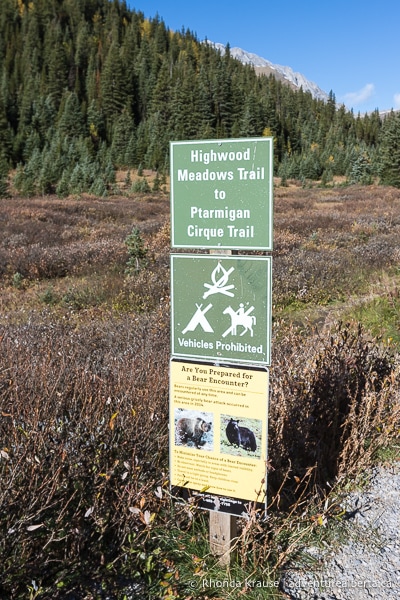
The Pocaterra Ridge hike begins at the Highwood Meadows Day Use Area. The parking lot is way too small considering that two very popular hikes start here, so you will need to arrive early to get one of the 40 or so parking spots.
The trailhead beside the parking lot is marked with a sign saying “Highwood Meadows Trail to Ptarmigan Cirque Trail”. This is also where the Pocaterra Cirque and Pocaterra Ridge hikes begin, even though the sign doesn’t indicate that. The Pocaterra Ridge hike is on an unofficial trail, so it’s not maintained or promoted by Alberta Parks.
Leaving the parking lot on Highwood Meadows Trail, you’ll cross a wooden bridge then walk through an area of shrubs and trees beside the highway. Soon you’ll arrive at a junction where Highwood Meadows Trail veers right and a double dirt track continues straight through a meadow. Go straight here (there’s a sign saying “Fragile Area”).
.jpg)
.jpg)
Now that you’re on Pocaterra Cirque Trail, follow the dirt track through the meadow then into the forest.
.jpg)
Once you’re in the trees, it’s not long until the trail turns left and then starts ascending up a small hill. There is some trail braiding, so try to stay on the most trodden route and keep a lookout for flagging tape on trees marking the way.
.jpg)
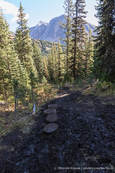
As you continue hiking through the forest, the trail will have some ups and downs, but overall it loses elevation. At the end of the forest, about 1.5 km into the hike, the trail arrives at an open meadow framed by mountains and larch trees.
.jpg)
Here you’ll get your first view of South Pocaterra Ridge looming above a forested valley. From this spot you can also see Highwood Ridge and Mount Pocaterra.
.jpg)
.jpg)
As you cross the meadow below the ridge, there are great views to your right of Elpoca Mountain at the end of the valley, as well as Pocaterra Ridge.
.jpg)
.jpg)
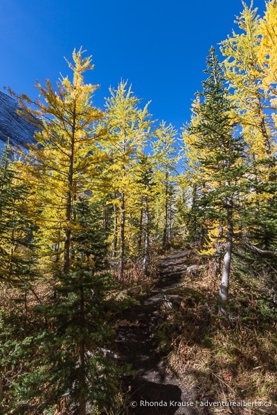
Further ahead the trail passes through an area of scree then proceeds into a patch of larch trees.
.jpg)
As you walk through the trees, you’ll be able to enjoy some glimpses of South Pocaterra Ridge and the summit that is the final destination of this hike.
.jpg)
Soon the trail exits the trees and you’ll be walking alongside the edge of a larch forest as the path starts to gradually gain a bit of elevation.
.jpg)
.jpg)
.jpg)
Keeping straight on the path, it won’t be long until you reach a scenic small tarn. As you walk along the rock-strewn shoreline there are wonderful views of the south summit of Pocaterra Ridge.
.jpg)
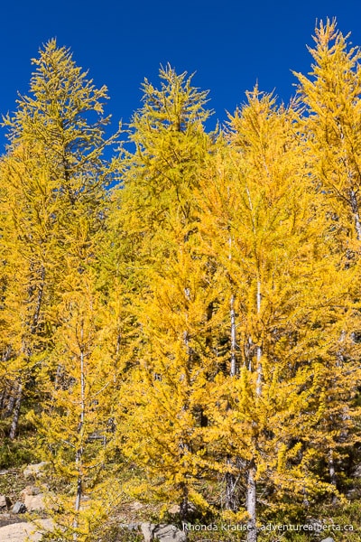
This spot is especially pretty during the second half of September when the larch trees that frame one side of the tarn have bright yellow needles.
.jpg)
.jpg)
Beyond the tarn, the trail continues slightly uphill along the edge of the larch forest. From the path you get a close-up view of the larch trees and their soft, golden needles.
.jpg)
A little further ahead and around a bend, Mount Pocaterra makes an appearance. The contrast between its rugged, grey rockface and the delicate, sunny larch trees is a beautiful scene.
.jpg)
The path still follows closely beside the larch before once again it’s framed on both sides by trees as it passes through another small patch of forest. On the other side, the path arrives at a wide open meadow overlooked by Mount Pocaterra and Pocaterra Ridge.
.jpg)
.jpg)
.jpg)
On the left near the start of the meadow there’s a trail that goes to Grizzly Col and then up Mount Tyrwhitt. Don’t go this way- keep straight to walk through the meadow on what now is Pocaterra Ridge Trail.
From this meadow you get a good sense of just how long and steep the approach is to South Pocaterra Ridge. If you’re reconsidering hiking up to the summit you can turn around here, but it is worthwhile to go all the way to the base of the ridge, especially if you want to see more larch trees.
.jpg)
Continuing on Pocaterra Ridge Trail, you’ll come to a creek at the end of the meadow. Here the trail turns left and begins to make a large U-shape around the start of the creek. After passing the creek, the rocky trail turns right and then left (at the time of this writing there was some flagging tape around a tree trunk to show the way).
.jpg)
.jpg)
Next the trail goes through an area of trees and ascends up a rocky hill. There’s a large, jagged rock in the middle of the path, so just choose a route that you’re comfortable with to go around it.
.jpg)
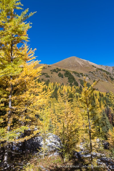
As you continue on the trail towards Mount Pocaterra you’ll be surrounded by more larch trees. Eventually the forest opens up allowing for better views of Mount Tyrwhitt on the left, Mount Pocaterra straight ahead, and Pocaterra Ridge on the right.
.jpg)
.jpg)
.jpg)
The trail proceeds between the base of a mountain and the larch forest then turns right and crosses a small stream (your feet won’t get wet). This is where the tough part begins, so it’s a good time to rest before embarking on the steep hike to Pocaterra Ridge.
.jpg)
.jpg)
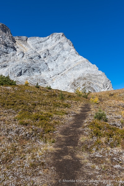
From this point on you’ll be making a steady ascent up the south end of Pocaterra Ridge. You’ll likely need plenty of breaks, but at least there are stunning views to enjoy while you catch your breath.
.jpg)
From the creek, the trail makes a few zig-zags up the bottom of the hill then straightens out.
Soon into the climb you’ll notice that the path splits- one side turns right into the trees while the other goes straight, keeping near the edge of a slope. You can take either one, as they later meet up, but going right seems to be the more popular choice. For some variety, you could take the right path on the way up, and keep straight beside the slope on the way down.
.jpg)
Heading right at the junction, you’ll briefly pass through some trees then arrive at a viewpoint overlooking the larch-filled valley you just hiked through.
.jpg)
This spectacular view keeps getting better the higher you go up the ridge. As nice as it was to hike in close proximity to the larch trees, it’s just as much fun to see them from above.
.jpg)
.jpg)
Keep following the path up the hill until it meets up with the other trail. Now there will only be one route up to Pocaterra Ridge, so keep on the path to avoid trampling the vegetation.
Continuing your journey up to the ridge, Mount Pocaterra will be close by on your left. You may even notice what looks like a small cave in the mountainside.
.jpg)
As you persevere up the steep hill, there will be gorgeous views both beside and behind you. You’ll be able to see the larch forest below Highwood Ridge, as well as Grizzly Col and Mount Tyrwhitt behind you.
.jpg)
.jpg)
.jpg)
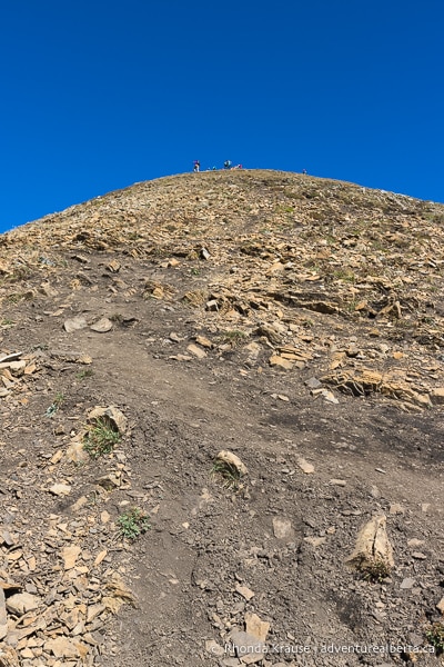
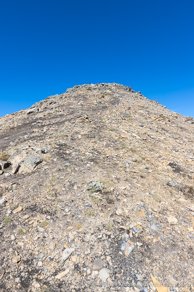
The closer you get to the top of Pocaterra Ridge, the steeper and rockier the terrain becomes. There’s no shame in taking breaks to catch your breath and soothe your burning legs, especially since there are so many rocky peaks to admire while you rest.
.jpg)
.jpg)
Once you finally arrive at the south summit of Pocaterra Ridge, you’ll be rewarded with a stunning panoramic view of mountains in the Opal Range and Elk Range. You can even look down into the valley between Mount Pocaterra and Pocaterra Ridge.
.jpg)
.jpg)
Straight ahead you’ll see Pocaterra Ridge leading north towards Gap Mountain and Elpoca Mountain. Some people choose to hike Pocaterra Ridge Trail all the way to its north end, but this requires some advance planning since you’ll need to have a vehicle waiting at the Little Highwood Pass Day Use Area.
.jpg)
After admiring the view from South Pocaterra Ridge, head back down the hill the same way as before. On the return hike you’ll get to enjoy more lovely views of Mount Tyrwhitt and the larch trees at Pocaterra Cirque.
.jpg)
.jpg)
.jpg)
Once you get lower on the ridge, this time stay straight on the path closest to the mountainside. You’ll pass through an area of small larch trees then descend on a dirt trail above the slope.
.jpg)
.jpg)
.jpg)
At the bottom of the hill you’ll arrive back at the creek. For the rest of the hike you’ll be retracing your steps on the same trail as before- walking alongside the forest of larch, passing through the meadow and by the pond, then hiking in the shady woods.
.jpg)
.jpg)
.jpg)
After exiting the woods, make your way through Highwood Meadows and back to the parking lot at the trailhead.
.jpg)
Review of the South Pocaterra Ridge Hike
The South Pocaterra Ridge hike is an enjoyable trip filled with incredible scenery, especially during larch season when you can admire the fall colours from above and while immersed in the forest.
.jpg)
.jpg)
There’s no doubt that this is one of the best larch hikes in Kananaskis, but the trail is still worth exploring in the summer because of the impressive mountain views, beautiful valleys, and attractive meadows.
.jpg)
.jpg)
Pocaterra Ridge Trail is easy to follow, even though it’s not marked with signs, and isn’t physically taxing until you get to the ridge. It’s a great hike to enjoy at a leisurely pace because the journey is just as beautiful as the destination.
.jpg)
Pictures of the South Pocaterra Ridge Hike
Here are some more photos taken while hiking to the ridge’s south summit via Pocaterra Cirque Trail and Pocaterra Ridge Trail.
.jpg)
.jpg)
.jpg)
.jpg)
.jpg)

.jpg)
.jpg)
.jpg)
.jpg)
.jpg)
.jpg)
.jpg)
.jpg)
.jpg)
.jpg)
.jpg)
.jpg)
.jpg)
.jpg)
.jpg)
.jpg)
.jpg)
.jpg)
.jpg)
.jpg)
.jpg)
.jpg)
.jpg)
.jpg)
.jpg)
.jpg)
.jpg)
Tips for Hiking Pocaterra Ridge Trail
Location: Pocaterra Ridge is located in Peter Lougheed Provincial Park in Kananaskis Country. The trailhead is at the Highwood Meadows Day Use Area/Highwood Pass parking lot beside Highway 40.
Getting to the Pocaterra Ridge Trailhead: From Highway 1, turn south onto Highway 40 (Kananaskis Trail) and follow it all the way to Highwood Meadows Day Use Area at Highwood Pass. The parking lot will be on the right. If the lot is full, you’ll likely see vehicles parked on the sides of the road.
- Highway 40 is closed south of the Kananaskis Lakes Trail junction from December 1 to June 15.
Best Time to Hike Pocaterra Ridge Trail: Pocaterra Ridge can only be accessed from June 15- December 1 due to a seasonal closure of the stretch of highway that goes to the trailhead. July and August is a good time to hike Pocaterra Ridge Trail, but it’s most beautiful during the last two weeks of September when the larch needles turn golden yellow.
- It’s not recommended to hike Pocaterra Ridge Trail in the winter (avalanche risk) or if it’s wet/muddy.
Kananaskis Conservation Pass: To park in Kananaskis Country you need to purchase a daily or annual Kananaskis Conservation Pass. It can easily be bought online and is registered to your licence plate (there’s no physical pass to be displayed in your vehicle). You can also purchase a pass at the Kananaskis Visitor Information Centre on Highway 40 (in person or by using the WiFi).
Facilities: At the trailhead there are outhouses and a picnic table.
Visitor Guidelines and Safety: This hike is in bear country so bring bear spray, make noise while hiking, and educate yourself on what to do if you encounter one. Bears are known to frequent the Highwood Pass area.
- Avoid going off trail and only hike when the ground is dry. This helps protect the fragile alpine environment and prevents trail braiding.
- Weather changes quickly in the mountains and it can be very windy on the ridge, so come prepared with layers.
- If you use a hiking app, download your trail map ahead of time since there’s no cell service.
- Leave no trace by packing out your garbage. If the bins at the trailhead are full, take your garbage home with you.
Gear and What to Bring: Wear hiking boots with ankle support and a sturdy sole. Hiking poles are recommended for the steep ridge trail.
.jpg)
Accommodations in Canmore and Kananaskis
For your convenience, here is a list of HOTELS IN CANMORE and KANANASKIS. Please consider booking your Canmore and Kananaskis accommodations through the included link. It costs nothing extra and helps support this website. Thank you!
Nearby Hikes
You may also enjoy these other trails in Kananaskis:
Shop for Alberta & Adventure Themed Merchandise
.jpg)
.jpg)
.jpg)
.jpg)
.jpg)
.jpg)
Visit our store for more Alberta, nature, and adventure inspired products.


