
Purchases made through links earn us a small commission, at no extra cost to you.
The Rawson Lake and Sarrail Ridge hike is a journey that will deliver you to some of the most mesmerizing views in Kananaskis Country.
.jpg)
This two-part hike first arrives at the shore of beautiful Rawson Lake where you’ll be greeted with a commanding view of Mount Sarrail. The second segment climbs steeply on an unofficial trail to the top of Sarrail Ridge, where there’s a breathtaking panorama of Upper and Lower Kananaskis Lakes.
.jpg)
While the Rawson Lake hike is considered moderate, the Sarrail Ridge hike is far more challenging and should only be attempted if the trail is dry.
.jpg)
When Rawson Lake Trail is combined with Sarrail Ridge Trail, it creates a diverse hike with a variety of scenery and terrain that will wow hikers of all levels.
.jpg)
.jpg)
Sarrail Ridge Hike (via Rawson Lake)
Distance: 12.2 km round trip
Difficulty: Moderate to Rawson Lake, strenuous to Sarrail Ridge
Elevation Gain: 659 m
Surface: Packed dirt with exposed roots and rocks, loose dirt going up to the ridge
Trail Type: Out and back
Time: 5- 6.5 hours (at a moderate pace with breaks at Rawson Lake and Sarrail Ridge)
Trailhead: Beside the Upper Kananaskis Lake parking lot
.jpg)
Sarrail Ridge Trail Description
The hike to Rawson Lake and Sarrail Ridge starts at the Upper Kananaskis Lake Day Use Area. From the parking lot, walk past the outhouses to get to the Upper Lake Trailhead, which is the beginning point of this hike. Here there’s a large sign with some information about the area and a trail map.
.jpg)
.jpg)
A few metres up the path you’ll see a sign indicating that the Rawson Lake trailhead is 1.2 km away. You’ll be hiking on the Upper Kananaskis Lake Trail until you reach the signed junction with Rawson Lake Trail.
.jpg)
As you continue straight on Upper Kananaskis Lake Trail you’ll be surrounded by trees, but there are several spots with openings to view the lake. This lakeside walk is mostly flat and is the easiest section of this hike.
.jpg)
.jpg)
As the tree-framed trail zigzags near the shore, it offers more fleeting views of the lake on one side and the mossy forest floor on the other.
.jpg)
.jpg)
Eventually the trail arrives at a bridge crossing over Sarrail Creek as it tumbles down a hill into the lake. This small waterfall is a pretty place to stop for a few pictures before continuing towards the Rawson Lake trailhead.
.jpg)
.jpg)
After passing the Sarrail Creek waterfall, the trail turns right then gradually curves left, still roughly following the lake’s shoreline. Soon you’ll arrive at a marked trail junction. The sign here indicates that Rawson Lake is 2.2 km away. Keep left at the junction to get on Rawson Lake Trail.
.jpg)
At the Rawson Lake trailhead you’ll see the first in a series of interpretive signs that have been installed along the hike. These signs provide some interesting information about Rawson Lake and the surrounding forest.
At this point in the hike the trail begins a steady, but not too steep, ascent that doesn’t level off until you’ve almost reached the lake. During the approach, you’ll pass through an old growth forest and see many dead, fallen trees.
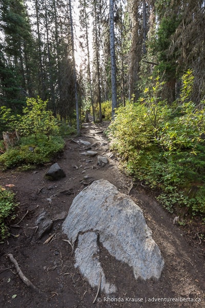
With the gain in elevation, there are more exposed rocks and roots on the trail. The path can get muddy in areas with less tree cover, so elevated walkways have been made with split logs to prevent erosion by hikers.
.jpg)
.jpg)
As you get closer to the lake, watch for a gap in the trees where you can look down from the trail to get a glimpse of Rawson Creek trickling through the forest. The water is even clear enough to see the rocky creek bed.
.jpg)
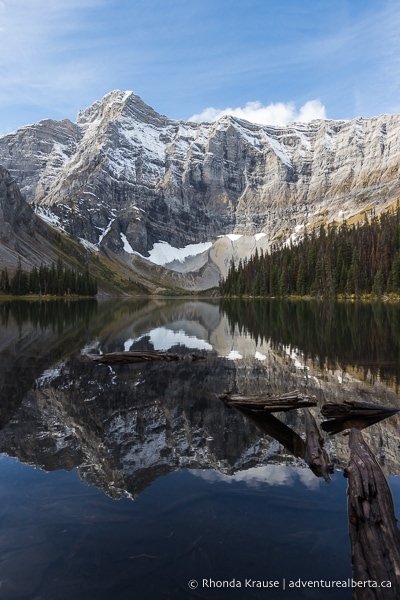
A short distance later you’ll finally arrive at Rawson Lake. From the shore there’s a gorgeous view of Mount Sarrail framing the far end of the lake.
.jpg)
On a calm day the lake’s clear water is like glass, perfectly reflecting Mount Sarrail and the tree-lined shore.
.jpg)
After taking in the scenery, continue following the path through a small area of trees then along the south shore for a different vantage point of the lake and surrounding mountains.
.jpg)
From this spot you also get a good preview of the final destination of this hike, as you can see Sarrail Ridge looming over the lake’s north shore.
.jpg)
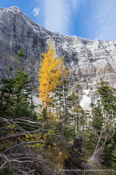
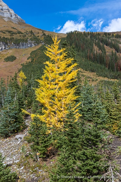
During this shore walk you’ll pass by a green outhouse and start to see some larch trees. While the Rawson Lake and Sarrail Ridge hike doesn’t have as many of these high altitude trees as other larch hikes in Kananaskis, you’ll be able to see a few at the end of the lake and on Sarrail Ridge.
.jpg)
.jpg)
Keep following the trail beside the rocky mountainside, then past a group of trees until there’s an unobstructed view of Mount Sarrail. You’ll notice a sign saying “End of Trail” marking the finish point of the official Rawson Lake hike. Anything beyond this sign is not an official trail so is unmaintained.
.jpg)
.jpg)
.jpg)
Before deciding to continue on to the Sarrail Ridge hike, you should assess the weather, keeping in mind that conditions change quickly in the mountains. This hike proceeds on a very steep trail that has loose dirt and is open to the elements. It would be slick and treacherous in the rain (or if still wet from a previous storm). Even when dry, the trail has some challenges.
.jpg)
If conditions are good and you’re prepared for the Sarrail Ridge hike, walk along the rocky shore to the end of Rawson Lake.
.jpg)
Along the way you’ll have great views of Mount Sarrail straight ahead and Sarrail Ridge to your right.
.jpg)
At the end of the lake the trail passes through an area of short spruce and fir trees. You’ll even see a few larch in the mix. Since the trees are so small, you still get to enjoy views of the lake.
.jpg)
As you walk along the path towards the ridge, you’ll start to get a sense of just how high Sarrail Ridge is, even though the trail up it hasn’t come into full view yet.
.jpg)
.jpg)
Once you reach the other side of the lake and the base of Sarrail Ridge, the steep ascent up Sarrail Ridge Trail begins.
From this point on, you’ll be steadily gaining elevation. It’s a long, steep, unrelenting climb to the top of the ridge, with a few additional challenges on route.
.jpg)
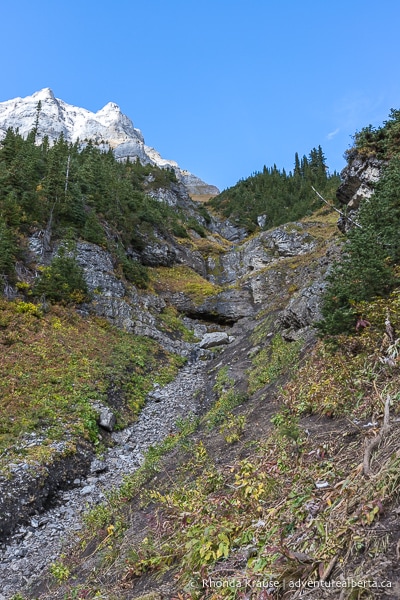
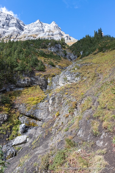
At the start, Sarrail Ridge Trail goes beside a drainage track from a steep, rocky gully. Once you see the gully, don’t worry- this is not the approach up to the ridge. You’ll be keeping to the right.
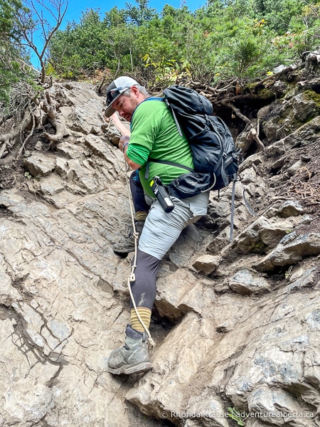
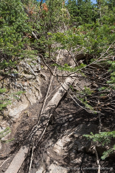
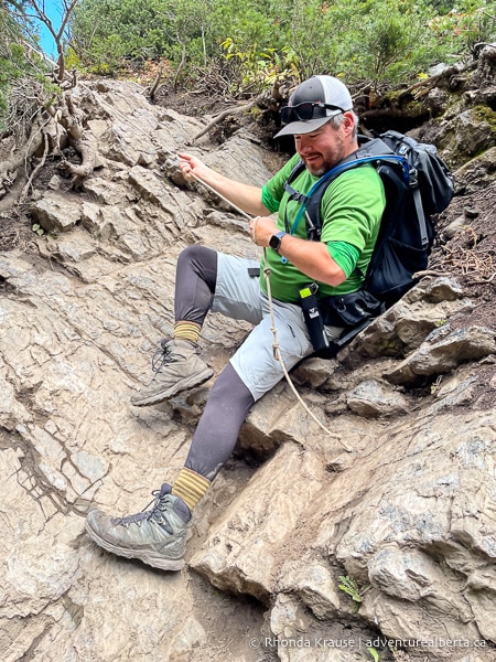
Here you’ll encounter the first challenge of the Sarrail Ridge hike- a short scramble. To help hikers get up the rocks, someone tied a rope to the base of a tree further up the path. It’s helpful to use the rope both on the ascent and descent, but you may have to wait your turn if the trail is busy.
.jpg)
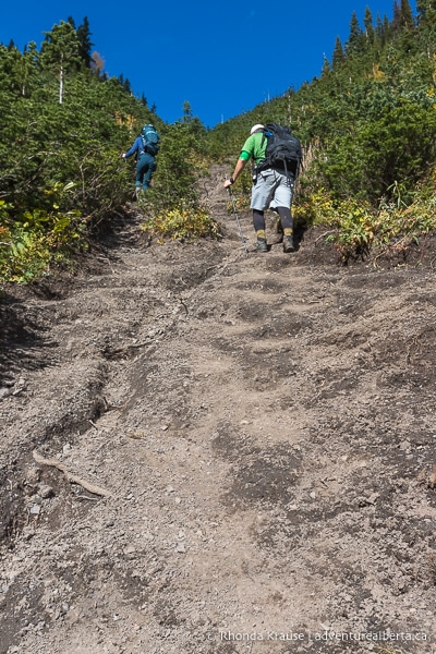
After this mini scramble there are a few switchbacks, then the trail goes straight up the rest of the way.
.jpg)
.jpg)
Since the path is loose dirt, it can be slippery even when dry. Some natural “steps” have formed in the dirt that act as footholds to make the ascent easier.
As you get higher there are fewer trees framing the trail. Soon you’ll arrive at a slope-side alpine meadow. Keep on the most trodden path to prevent trail braiding and unnecessary erosion.
.jpg)
.jpg)
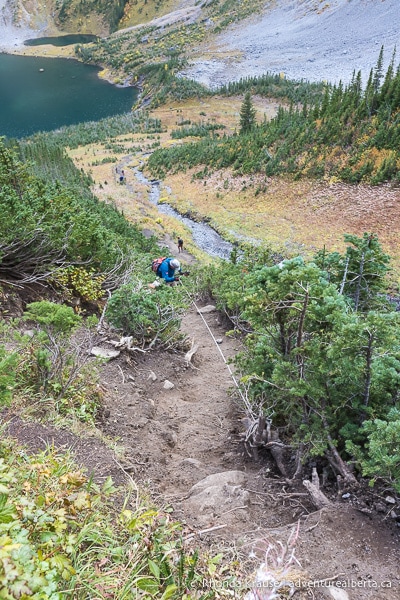
Now that you’re getting closer to the ridge there are good views of Rawson Lake behind you. It’s always nice to have something pretty to look at while catching your breath!
.jpg)
Continuing on, the trail will eventually curve to the right for the final approach to the ridge. Get ready for amazing views ahead!
.jpg)
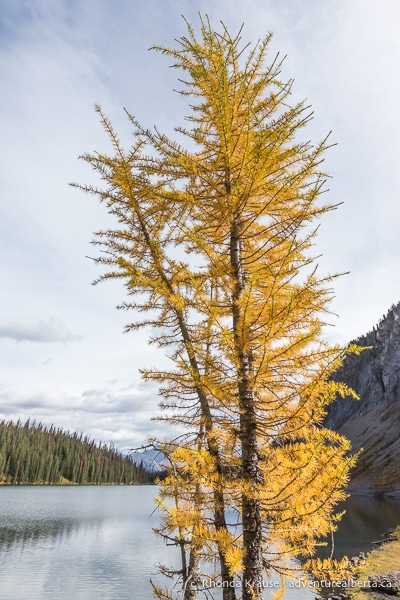
Finally, at the top of Sarrail Ridge you’ll be rewarded with a sensational view of the Kananaskis Lakes, perfectly framed by the rocky walls of the ridge. In autumn, the larch trees down below really stand out with their golden needles.
.jpg)
As much as you might be tempted to linger at this first viewpoint, it’s worth it to continue up a little bit higher and further along the ridge. Follow the trail past a group of larch trees then make your way across the ridge, stopping near the base of the rocky, pointed summit.
.jpg)
.jpg)
All along the ridge there are fantastic views of Upper and Lower Kananaskis Lakes on one side, and Rawson Lake on the other. Completing the scene is the south peak of Mount Indefatigable overlooking both Kananaskis Lakes.
.jpg)
.jpg)
.jpg)
Once you’re satisfied with your time on Sarrail Ridge, make your way back to Rawson Lake by going down the same steep trail as before. Even though the hike is downhill, it’s still challenging because the loose dirt makes your feet slip.
After you return to Rawson Lake, the rest of the hike is easy because the trail is either flat or gradually goes downhill. Just retrace your steps back to the parking lot.
.jpg)
Review of the Rawson Lake and Sarrail Ridge Hike
The Rawson Lake and Sarrail Ridge hike is a great outing in Kananaskis Country. The hike offers a little bit of everything as far as scenery goes- a waterfall, forest, beautiful lakes, mountains, and sweeping summit views.
.jpg)
The progression of this hike is manageable too. It starts off easy and flat, then has a moderate uphill section, gets flat again at Rawson Lake, then ends with a challenging ascent to Sarrail Ridge. Going from easy to hard means that a beginner hiker isn’t going to encounter a section of trail that’s beyond their comfort level. If need be, people can turn back at Rawson Lake before getting into more advanced terrain.
.jpg)
As for the steep Sarrail Ridge trail, it’s a literal breathtaking hike to a breathtaking view. People who have experience with very steep trails might not find it so bad, especially because of the natural footholds/”tiny steps” that have formed in the dirt. However, the average hiker (and those that don’t come prepared with poles) will be challenged.
.jpg)
Whether you just do the Rawson Lake hike, or also choose to tackle the Sarrail Ridge hike, you’ll get to enjoy some wonderful scenery and a satisfying day on the trails.
.jpg)
Pictures of the Sarrail Ridge Hike
Here are some more photos of the hike to Rawson Lake and Sarrail Ridge.
.jpg)
.jpg)
.jpg)
.jpg)
.jpg)
.jpg)
.jpg)
.jpg)
.jpg)
Tips for Hiking Sarrail Ridge Trail
Location: Sarrail Ridge is located in Peter Lougheed Provincial Park in Kananaskis Country. The trailhead is at the Upper Kananaskis Lake Day Use Area parking lot, approximately 93 km from Canmore.
Getting to the Trailhead: From Highway 1, turn south onto Highway 40 (Kananaskis Trail) and follow it until you reach Highway 742 (Kananaskis Lakes Trail). Stay on Kananaskis Lakes Trail until you see signs directing you to the Upper Lake Day Use Area (will be a left turn). After turning off Kananaskis Lakes Trail, follow the road past the boat launch and first parking area until you reach the lot and picnic area at the end of the road.
Kananaskis Conservation Pass: To park in Kananaskis Country you need to purchase a daily or annual Kananaskis Conservation Pass. It can easily be bought online and is registered to your licence plate (there’s no physical pass to be displayed in your vehicle). You can also purchase a pass at the Kananaskis Visitor Information Centre on Highway 40 (in person or by using the WiFi).
Best Time to Hike Sarrail Ridge: The Rawson Lake and Sarrail Ridge hike is best done in the summer and early fall (July- late September). Sarrail Ridge should only be attempted if the trail is dry.
- The last two weeks of September are typically when you can see the golden needles of the larch trees.
- In winter it’s common for snow to be 2.5 m deep in this area. It’s not advised to go beyond Rawson Lake in the winter because of avalanche risk.
Facilities: At the trailhead there are outhouses and picnic tables. There’s also an outhouse at Rawson Lake.
Visitor Guidelines and Safety: This hike is in bear country so bring bear spray, make noise while hiking, and educate yourself on what to do if you encounter one.
- Weather can change quickly in the mountains so come prepared with layers.
- If you use a hiking app, download your trail map ahead of time in case there’s no cell service.
- Leave no trace by packing out your garbage. If the bins at the trailhead are full, take your garbage home with you.
Gear and What to Bring: Hiking poles are essential for the Sarrail Ridge hike because they take strain off your knees, add some thrust when going uphill, increase stability on the loose dirt, and can help you catch your balance if you slip.
- Sturdy hiking shoes with good grips or hiking boots with ankle support are recommended.
.jpg)
Accommodations in Canmore and Kananaskis
For your convenience, here is a list of HOTELS IN CANMORE and KANANASKIS. Please consider booking your Canmore and Kananaskis accommodations through the included link. It costs nothing extra and helps support this website. Thank you!
Nearby Hikes
You may also enjoy these other trails in Kananaskis:
Shop for Alberta & Adventure Themed Merchandise
.jpg)
.jpg)
.jpg)
Visit our store for more Alberta, nature, and adventure inspired products.


