
Purchases made through links earn us a small commission, at no extra cost to you.
The Rawson Lake hike is a half-day trip to a stunning glacier-carved cirque and alpine lake in Kananaskis Country.
Framed by trees with Mount Sarrail towering at the head of the cirque, there’s plenty of natural beauty to appreciate at the end of Rawson Lake Trail. On a calm morning, the surrounding scenery is perfectly reflected in Rawson Lake’s clear water.
.jpg)
While the final destination is definitely the main highlight, the Rawson Lake hike also showcases views of Upper Kananaskis Lake, a small waterfall, and an old growth forest.
.jpg)
Rawson Lake Hike
Distance: 7.8 km round trip
Difficulty: Moderate
Elevation Gain: 300 m
Surface: Packed dirt, areas with exposed roots and rocks
Trail Type: Out and back
Time: 2.5- 3.5 hours
Trailhead: Beside the Upper Kananaskis Lake parking lot
.jpg)
Rawson Lake Trail Description
The hike to Rawson Lake starts at the Upper Kananaskis Lake Day Use Area. The trailhead is at the south end of the parking lot, just beyond the outhouses. You’ll see a large sign with some information about the area and a trail map.
.jpg)
.jpg)
Don’t let the name on the sign (Upper Lake Trailhead) confuse you- this is the access point for Rawson Lake. The first section of the Rawson Lake hike proceeds along the Upper Kananaskis Lake Trail. A little over a kilometre later, the path arrives at the Rawson Lake trailhead.
As you depart from the Upper Lake trailhead, you’ll be following a wide, flat path into a mature forest of Engelmann spruce and subalpine fir. A snow-capped mountain can be seen straight ahead in the distance. A few metres later you’ll pass a sign saying that the Rawson Lake trailhead is 1.2 km away.
.jpg)
Soon there’s a big gap in the trees offering a wonderful view of Upper Kananaskis Lake and the mountains that surround it. If you want, walk a few steps to the rocky shore for a wider view of the scenery.
.jpg)
.jpg)
Continuing down the tree-framed path, there will be more peekaboo views of Upper Kananaskis Lake, as the trail sticks fairly close to the shoreline the entire way to Rawson Lake Trail. On your left you’ll see small streams and moss carpeting the shady, forest floor.
.jpg)
.jpg)
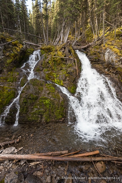
About 1.1 km into the hike you’ll arrive at Sarrail Creek. From the bridge you get a close look at a 10 m tall waterfall tumbling into the lake.
.jpg)
After crossing the bridge over Sarrail Creek, the trail turns right then gradually curves left, still roughly following the lake’s shoreline. Soon a trail junction comes into view and the sign indicates that Rawson Lake is 2.2 km away. Keep left at this junction to get on Rawson Lake Trail.
.jpg)
At the Rawson Lake trailhead there’s a sign with some brief information about the Rawson Lake hike. This is the first in a series of interpretive panels along the trail that share some interesting information about Rawson Lake and the surrounding environment.
Now that you’re on Rawson Lake Trail, the hike shifts from easy to moderate as it embarks on a steady ascent towards the lake. The trail isn’t steep, and there are switchbacks, but it does require some stamina since it won’t level off until you’re almost at the lake.
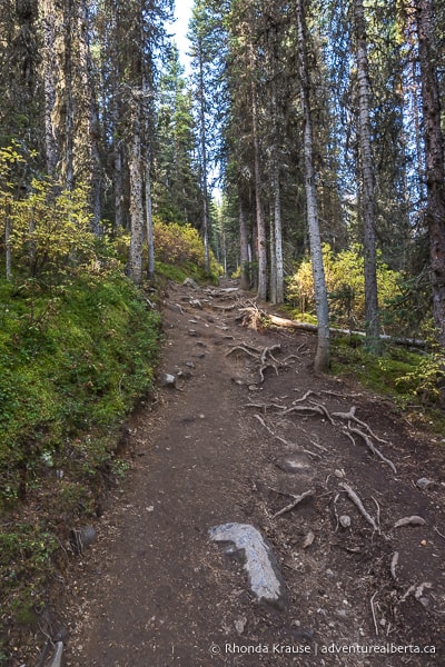
During this segment of the Rawson Lake hike you’ll pass through an old growth forest. There are many dead, fallen trees and you may even see or hear some woodpeckers searching for a snack.
Once the ascent is done, the trail levels out and crosses a damp area of the forest. Split logs have been put down so hikers don’t cause more erosion by walking through the mud.
.jpg)
Nearing the lake, you’ll be able to look down from the trail and get glimpses of Rawson Creek flowing through the forest. The water looks so clear and refreshing!
.jpg)
It’s not much further until Rawson Lake suddenly appears. From the shore you get a spectacular view of Mount Sarrail curving around the western end of the lake. This limestone headwall is the crowning glory of this glacial cirque and its reflections in the lake are dazzling.
.jpg)
The hike is not over yet, as Rawson Lake Trail continues down the southeast shore towards Mount Sarrail. Walking along the forested path there will be several spots where you can enjoy more views of Rawson Lake and Sarrail Mountain, as well as Sarrail Ridge on the north shore.
.jpg)
.jpg)
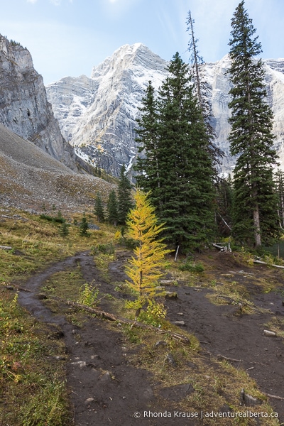
After passing by a green outhouse, the trail proceeds along the edge of a small meadow below a rocky cliff. You’ll even see a few larch trees.
.jpg)
Keep straight on the path until you come to an unobstructed view of Sarrail Mountain and the west end of the lake. This is the official finish point of the Rawson Lake hike, as indicated by a sign saying “End of Trail.”
.jpg)
If you want to extend your hike, you can continue along the rocky shore to the end of Rawson Lake. From there, if you’re prepared to tackle some steep terrain, you can embark on the challenging but rewarding Sarrail Ridge Hike, but note that this is not an official trail and is unmaintained.
Once you’re finished visiting Rawson Lake, return to the trailhead on the same path you hiked in on.
.jpg)
Review of the Rawson Lake Hike
The Rawson Lake hike is an enjoyable, relaxed trip to one of the most exquisite cirques in Kananaskis Country. The lake’s beauty is enhanced by the wonderful reflections of Sarrail Mountain.
.jpg)
While people of all skill levels can enjoy Rawson Lake Trail, it’s especially good for beginners and intermediate hikers. The trail is easy to follow and well designed, so there’s a gradual gain in elevation instead of being overly steep.
The ease of access to Rawson Lake, and of course its stunning setting, makes this one of the more popular day hikes in Kananaskis. Thankfully, the lake is big enough to offer everyone their own quiet space on the shoreline, even on a busy summer weekend.
.jpg)
Tips for Hiking Rawson Lake Trail
Location: Rawson Lake is located in Peter Lougheed Provincial Park in Kananaskis Country. The trailhead is at the Upper Kananaskis Lake Day Use Area parking lot, approximately 93 km from Canmore.
Getting to the Rawson Lake Trailhead: From Highway 1, turn south onto Highway 40 (Kananaskis Trail) and follow it until you reach Highway 742 (Kananaskis Lakes Trail). Stay on Kananaskis Lakes Trail until you see signs directing you to the Upper Lake Day Use Area (will be a left turn). After turning off Kananaskis Lakes Trail, follow the road past the boat launch and first parking area until you reach the lot and picnic area at the end of the road.
Kananaskis Conservation Pass: To park in Kananaskis Country you need to purchase a daily or annual Kananaskis Conservation Pass. It can easily be bought online and is registered to your licence plate (there’s no physical pass to be displayed in your vehicle). You can also purchase a pass at the Kananaskis Visitor Information Centre on Highway 40 (in person or by using the WiFi).
Best Time to Hike Rawson Lake Trail: The Rawson Lake hike is best done in the summer and early fall (July- late September).
- In winter it’s common for snow to be 2.5 m deep in this area. It’s not advised to go beyond Rawson Lake in the winter because of avalanche risk.
Facilities: At the trailhead there are outhouses and picnic tables. There’s also an outhouse at Rawson Lake.
Visitor Guidelines and Safety: This hike is in bear country so bring bear spray, make noise while hiking, and educate yourself on what to do if you encounter one.
- Weather can change quickly in the mountains so come prepared with layers.
- If you use a hiking app, download your trail map ahead of time in case there’s no cell service.
- Leave no trace by packing out your garbage. If the bins at the trailhead are full, take your garbage home with you.
Gear and What to Bring: Wear hiking shoes/boots or supportive runners with a sturdy sole. Hiking poles are nice to have but not essential for the Rawson Lake hike (unless you have bad knees).
Fishing at Rawson Lake: There are cutthroat trout in Rawson Lake. For fishing it’s catch and release only (trout limit is 0). The use of bait is not allowed. Fishing is allowed from July 16- October 31. Consult the Alberta sportfishing regulations for more details.
.jpg)
Accommodations in Canmore and Kananaskis
For your convenience, here is a list of HOTELS IN CANMORE and KANANASKIS. Please consider booking your Canmore and Kananaskis accommodations through the included link. It costs nothing extra and helps support this website. Thank you!
Nearby Hikes
You may also enjoy these other trails in Kananaskis:
Shop for Alberta & Adventure Themed Merchandise
.jpg)
.jpg)
.jpg)
Visit our store for more Alberta, nature, and adventure inspired products.


