
Purchases made through links earn us a small commission, at no extra cost to you.
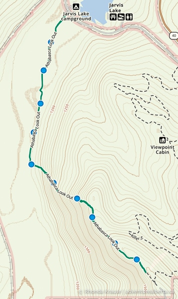
The Athabasca Lookout Trail leads to one of the most picturesque viewpoints in William A. Switzer Provincial Park near Hinton.
.jpg)
From the Athabasca Lookout Viewpoint, and at several spots along the forested ridge trail, you’ll get to enjoy panoramic views of the Joachim Valley and front ranges of the Rocky Mountains.
.jpg)
The Athabasca Lookout hike is a steep one, but you don’t need to go all the way to the end of the trail to experience the beautiful views it has to offer.
.jpg)
Athabasca Lookout Hike
Distance: 10.5 km round trip
Difficulty: Strenuous with an easy section
Elevation Gain: 409 m
Surface: Dirt, some rock
Trail Type: Out and back (can also be done as a point to point with two vehicles)
Time: 3.5- 4.5 hours
Trailhead: Across from the Jarvis Lake Campground (as described here) or at the end of the Hinton Nordic Centre Road (luge parking lot).
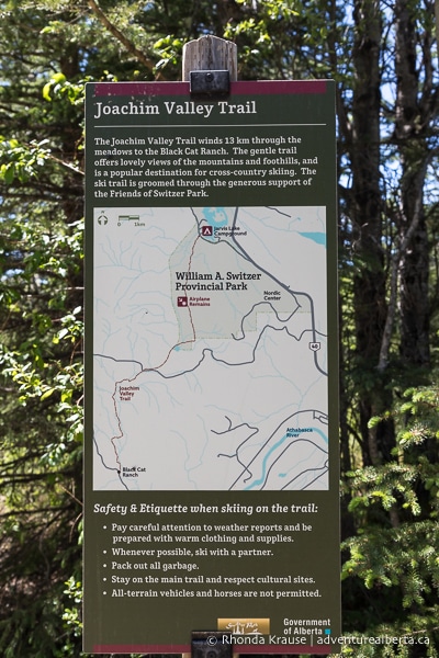
Athabasca Lookout Trail Description
Athabasca Lookout Trail has two trailheads at opposite ends, but the hike is most often done as an out and back rather than a point to point, since this would require a vehicle to be left at each end of the trail.
.jpg)
The shortest way to reach Athabasca Lookout is via the Hinton Nordic Centre. Starting from the end of the Hinton Nordic Centre Road, it’s approximately a 1 km uphill hike to the viewpoint.
The longer option is to start across from the Jarvis Lake Campground and access the steep Athabasca Lookout Trail via the Joachim Valley. This route has some additional points of interest and offers a better workout. The following trail description will explain the Athabasca Lookout hike starting from Jarvis Lake Campground.
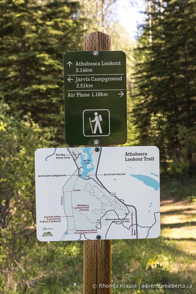
Across from the campground entrance you’ll see a short driveway leading to a closed gate. This is the trailhead and there’s room for a few vehicles to park here, but it’s not a proper lot. You could also check in the campground for visitor parking and then walk over.
.jpg)
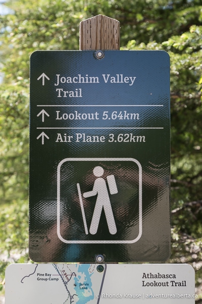
At the trailhead you’ll see some signs and a map indicating trail distances. To reach Athabasca Lookout Trail you first have to walk a portion of the Joachim Valley Trail.
Setting off from the trailhead you’ll be travelling along an old gravel road. This stretch is the easiest part of the hike because it’s flat all the way to the start of Athabasca Lookout Trail, about 2.5 km into the hike.
.jpg)
After travelling along the tree-framed road for about 0.8 km, the view opens up to showcase the valley’s meadows and surrounding foothills. This is also where the first point of interest on the trail is- an indigenous burial site where there are spirit houses covering the graves.
.jpg)
.jpg)
.jpg)
After the burial site the old road continues along the valley floor, passing through some pretty meadows.
.jpg)
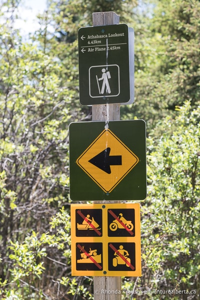
About 1.3 km into the hike you’ll see a signpost and arrow directing you to turn left onto a double track trail where motorized vehicles aren’t allowed. Follow this trail along the edge of the forest for approximately 1.2 km until you reach the next trail junction.
.jpg)
.jpg)
This junction is the Athabasca Lookout trailhead. Once again you’ll see a signpost with a map and distances. Turn left here and head into the forest (keeping straight on Joachim Valley Trail will take you to an old army training airplane).
.jpg)
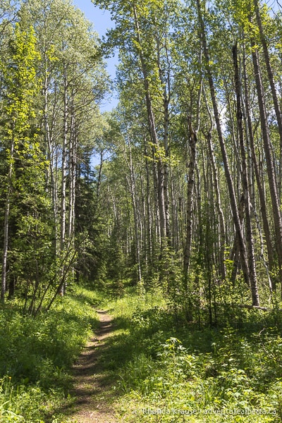
Very soon after embarking on Athabasca Lookout Trail you’ll begin the steep ascent towards the viewpoint. It’s a relentless 3 km climb that can feel never ending, but it’s worth it to persevere for the views.
As you get higher up on the trail there will start to be openings in the forest offering glimpses of the valley down below.
.jpg)
A little further ahead you’ll come to the first good viewpoint where you can enjoy a nicely framed view of the Joachim Valley from some boulders at the edge of the ridge trail.
.jpg)
.jpg)
Going onwards and upwards, there are more wonderful views as the trail proceeds above the hillside.
.jpg)
.jpg)
The path then becomes sheltered by trees and you’ll notice more boulders in the landscape as you keep gaining elevation.
.jpg)
.jpg)
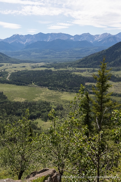
Later on the trail emerges from the trees, once again offering great vantage points for admiring the valley, foothills, and distant mountains.
.jpg)
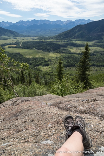
Soon you’ll come to a viewpoint that you might think (or hope) is the Athabasca Lookout, since it has such a beautiful perspective of the Joachim Valley, but it is not the official lookout point. That is still just under 2 km away.
.jpg)
This spot is a wonderful place to take a break because you can sit on the rocks and stretch your legs out while you admire the scenery.
.jpg)
This is also a good time to evaluate if you want to continue on with the hike, or if you’re done with the uphill grind. If you turn around here, you honestly won’t be missing out on much, since the scenery at Athabasca Lookout is pretty much the same as what you can see at this lower viewpoint.
.jpg)
Continuing towards the Athabasca Lookout Viewpoint, the trail alternates between being in the trees and being close to the cliff.
.jpg)
.jpg)
.jpg)
Next you’ll reach a section where the trail becomes rocky and passes over some boulders before re-entering the forest again.
.jpg)
.jpg)
.jpg)
Once you see the towers you’ll know you’ve finally arrived at the Athabasca Lookout. From this flat, rocky viewpoint you can enjoy a wide view of the Joachim Valley and Rocky Mountains to the west.
.jpg)
.jpg)
.jpg)
You can walk a bit further to where the towers are, which is actually the official Athabasca Lookout Viewpoint, but the view is better at this spot on the ridge. However, there is an interpretive sign at the towers with information about the area, if that’s of interest.
.jpg)
.jpg)
When you’re ready for the return hike, follow the same trail downhill to the bottom of the valley and back to the trailhead by the campground.
.jpg)
Review of the Athabasca Lookout Hike
Athabasca Lookout Trail isn’t for everyone, due to its leg burning steepness, but if you’re up for a challenge that pays off at the end then it’s a worthwhile hike.
The view at Athabasca Lookout is wonderful, however the best part of this hike is that you get samples on route of what the final destination has to offer. This helps keep motivation up, but also allows people who only want to complete a portion of the hike to experience some of the valley’s beauty from above.
.jpg)
.jpg)
.jpg)
Admittedly, the first part of the hike can be a bit boring, even though the scenery is nice. To cut down on hiking time you could bike the first 2.5 km of Joachim Valley Trail, then lock your bike to a tree when you hike up Athabasca Lookout Trail.
.jpg)
Tips for Hiking Athabasca Lookout Trail
Location: Athabasca Lookout Trail is located northwest of Hinton in William A. Switzer Provincial Park. The trailhead across from Jarvis Lake Campground is about 26 km from Hinton.
Getting to the Athabasca Lookout Trailhead: From Hinton go north on Highway 40 (signs for Grande Cache/Grande Prairie) then turn left onto Township Road 515A. Follow that all the way to Jarvis Lake Campground. The trailhead will be at a driveway on the left just before the campground entrance.
Best Time to Hike Athabasca Lookout Trail: This hike is best done from late spring through fall. The steep ascent can be miserable if conditions aren’t optimal, so it should be avoided if wet/muddy and on extremely hot days.
Facilities: None. The closest outhouses and water source are at Jarvis Lake Campground.
Visitor Guidelines and Safety: This hike is in bear country so bring bear spray, make noise while hiking, and educate yourself on what to do if you encounter one.
- Leave no trace by packing out your garbage.
Gear and What to Bring: Hiking poles are essential for this hike because they take strain off your knees, add some thrust when going uphill, increase stability, and can help you catch your balance if you slip.
- Hiking boots with ankle support and a sturdy sole are recommended.
- Bring plenty of water and some food.
.jpg)
Nearby Activities
You may also enjoy these other things to do in William A. Switzer Provincial Park:
Shop for Alberta & Adventure Themed Merchandise
.jpg)
.jpg)
.jpg)
Visit our store for more Alberta, nature, and adventure inspired products.


