
Purchases made through links earn us a small commission, at no extra cost to you.
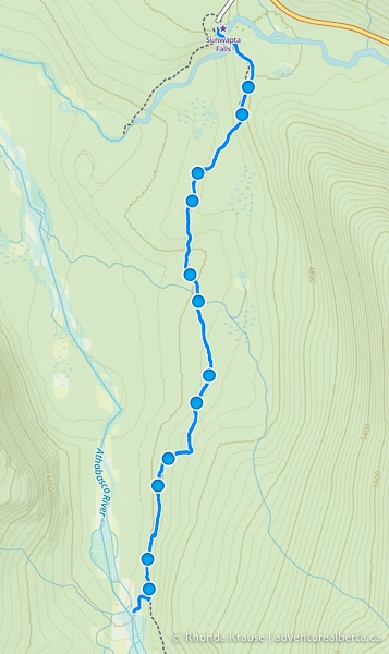
The hike to Big Bend in Jasper National Park will take you away from the crowds and deliver you to a peaceful backcountry campground beside the Athabasca River.
.jpg)
The route is along Chaba Trail, an old fire road that gradually descends through the forest towards a bend in the Athabasca River. For a longer hike, the trail continues past Big Bend to the Athabasca Crossing backcountry campground.
.jpg)
The Big Bend hike in Jasper is easily done as a day trip or you could plan to spend the night at the Big Bend campground.
.jpg)
Big Bend Hike
Distance: 12.7 km round trip
Difficulty: Moderate
Elevation Gain: 148 m
Surface: Packed dirt with exposed rocks and roots
Trail Type: Out and back
Time: 3.5- 4.5 hours (including lunch at the campground)
Trailhead: Sunwapta Falls parking lot about 500 m southwest of the Sunwapta Falls Rocky Mountain Lodge.
Big Bend Trail Description
The Big Bend hike begins at Sunwapta Falls, a popular tourist attraction along the Icefields Parkway. At the parking lot you’ll see a large sign with a brief description of the hikes that start here. There’s also a signpost nearby listing the trail destinations and their distances.
.jpg)
Chaba Trail (a.k.a. Big Bend Trail) is trail #126 and is shared with mountain bikers (although you likely won’t see many).
A few steps into this hike you’ll arrive at the Sunwapta Falls viewpoint. Cross the bridge spanning the gorge and head straight into the forest. There’s a sign nailed to a tree letting you know that Chaba Trail will lead to the Big Bend campground.

.jpg)
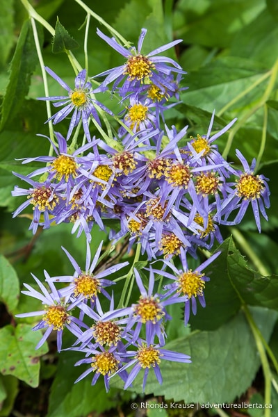
Leaving the waterfall behind, you’ll be embarking on a long, downhill hike on a wide trail. As you hike through the forest, you’ll see some wildflowers and berry bushes beside the trail. You might even see bear scat on the path, so make sure you have your bear spray accessible.
.jpg)
.jpg)
There’s nothing really notable on the trail until about 2.8 km into the hike, when you’ll come to a little log bridge crossing a stream. This is also where you’ll finally get a glimpse of the mountains through an opening in the forest.
.jpg)
.jpg)
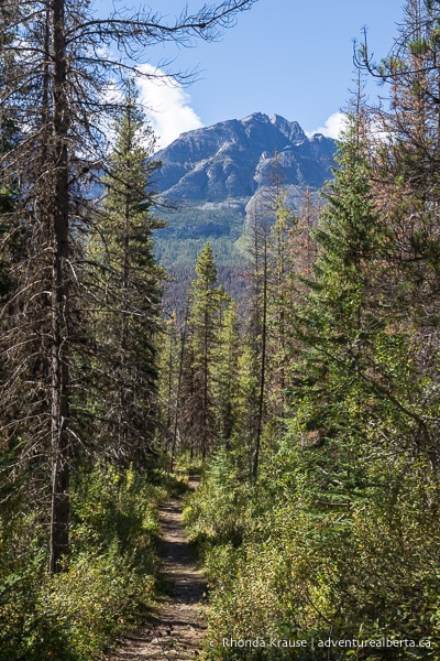
After crossing the stream the trail gains a little bit of elevation over the next 600 metres or so, then starts descending again. Straight ahead there’s a nice view of a mountain peak to enjoy.
During this last downhill section the trail starts to get closer to the Athabasca River, but it doesn’t come into view until you reach the bottom of the hill.
.jpg)
Here there’s a marked trail junction with directions and distances. Turn right to get to the Big Bend campground.
.jpg)
The path proceeds along a small body of water between the river and the forest, offering up beautiful views of the Rocky Mountains.
.jpg)
.jpg)
.jpg)
Soon you’ll arrive at a big bend in the Athabasca River where you’ll see a large sandbar.
.jpg)
.jpg)
A very short distance later the trail ends at the Big Bend campground. You’ll be arriving at the camp’s communal cooking/eating area where there’s a fire pit, bear lockers, picnic tables, and benches.
.jpg)
For the best view of the Athabasca River and surrounding mountains, take a seat on the bench next to the riverbank. From here you can even see a glacier nestled on one of the mountaintops.
.jpg)
.jpg)
After relaxing for a bit, take a short stroll downstream for a different perspective of the river. There’s another bench here and a partially sheltered meadow where the campground’s four tent pads are.
.jpg)
.jpg)
.jpg)
Before leaving the campground, if you need to use the “facilities” there’s a primitive outdoor toilet in a forested area uphill from the picnic area. Just follow the signs/trail markers.
.jpg)
When you’re ready to begin the return hike, follow the same trail as before. The trip back to Sunwapta Falls will be mostly uphill, but nothing steep.
.jpg)
Review of the Big Bend Hike
The Big Bend hike is one of the most peaceful day hikes in Jasper National Park, even though it starts out at a popular tourist attraction.
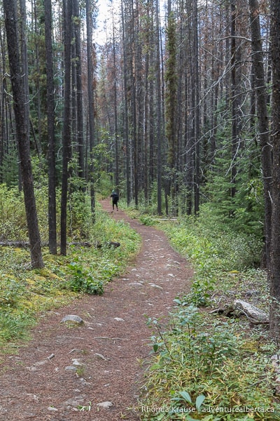
Chaba/Big Bend Trail is a great choice if you’re looking to experience a quiet walk in the forest, but the hike itself is unremarkable. What the trail lacks in inspiring scenery, Big Bend more than makes up for with its gorgeous riverside location and mountain views.
.jpg)
.jpg)
A nice bonus is that this hike has a comfortable spot at the end of the trail to enjoy lunch. That coupled with the area’s natural beauty makes Big Bend a place worth lingering.
.jpg)
Tips for Hiking Big Bend Trail
Location: Big Bend Trail is in Jasper National Park, just off the Icefields Parkway near Sunwapta Falls. It’s approximately 55 km southeast of the Jasper townsite and 49 km northwest of the Columbia Icefield Discovery Centre.
Getting to the Big Bend Trailhead: From Jasper, travel south on Highway 93 (Icefields Parkway) until you reach Sunwapta Falls Rocky Mountain Lodge. Turn right immediately after passing the lodge and drive about 500 m to the parking lot at the end of the road. There are signs on the highway marking the turnoff to Sunwapta Falls.
Best Time to Hike Big Bend Trail: The Big Bend hike is best done from late spring to early fall. If you do the hike in winter you will likely need snowshoes.
Facilities: There are outhouses and picnic tables at the trailhead parking lot. At the campground there are picnic tables and an outdoor toilet.
Visitor Guidelines and Safety: This hike is in bear country so bring bear spray and know how to use it. Don’t leave food unattended at the campground.
- Leave no trace by packing out your garbage. If bins are full, take your garbage home with you.
Gear and What to Bring: Wear hiking boots or shoes with a sturdy sole. Hiking poles aren’t essential.
.jpg)
Accommodations in Jasper National Park
For your convenience, here is a list of HOTELS IN JASPER NATIONAL PARK. The only accommodation option by the Big Bend hike is the SUNWAPTA FALLS ROCKY MOUNTAIN LODGE. Please consider booking your Jasper accommodations through the included link. It costs nothing extra and helps support this website. Thank you!
Nearby Hikes and Places to Visit
You may also enjoy these nearby trails and places to visit:
Shop for Alberta & Adventure Themed Merchandise
.jpg)
.jpg)
.jpg)
Visit our store for more Alberta, nature, and adventure inspired products.


