
Purchases made through links earn us a small commission, at no extra cost to you.
The Crypt Lake hike is one of the best known and most popular hikes in Waterton Lakes National Park. The trail obtained international recognition in 2014 when it was named one of the “World’s 20 Most Thrilling Trails” by National Geographic.
.jpg)
Crypt Lake Trail achieved this title because of some unique and adventurous features like a narrow cliff traverse, a ladder, a cramped natural tunnel, and cables for support when ascending/descending along a mountainside.
.jpg)
Before reaching the trail’s famous attributes, there’s a long uphill walk through a forest and then a mountain-framed valley. Crypt Lake trail also passes by several waterfalls before terminating at Crypt Lake cirque.
.jpg)
Crypt Lake Hike
Distance: 18.3 km round trip (not including the side trail to Hell-Roaring Falls)
Difficulty: Strenuous
Elevation Gain: 726 m
Surface: Dirt with exposed rocks and roots, some loose rock
Trail Type: Out and back
Time: 5.5- 7.5 hours (including breaks and lunch at the lake)
Trailhead: Crypt Landing dock on the east side of Upper Waterton Lake (requires a boat shuttle to access)
.jpg)
Crypt Lake Trail Description
The Crypt Lake trailhead is located on the eastern shore of Upper Waterton Lake and can only be reached by boat. There is a daily shuttle for hikers that leaves from the Waterton marina so your start time will depend on the morning boat schedule (more on that later).
.jpg)
After a 10- 15 minute boat ride across Upper Waterton Lake you’ll arrive at Crypt Landing. Here there is a dock, small beach, and an outhouse. The Crypt Lake trailhead is marked with a large sign at the edge of the forest.
.jpg)
.jpg)
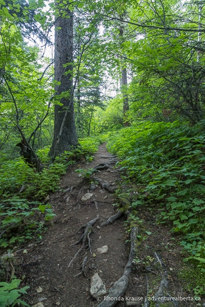
The Crypt Lake hike begins by ascending into the dense, lakeside forest. Soon the trail curves away from the lake and starts zigzagging uphill.
.jpg)
It’s not long until you arrive at a junction with the side trail to Hell-Roaring Canyon where you can see Hell-Roaring Falls. The sign says it’s 1 km to the canyon then the path will loop back to the Crypt Lake Trail around kilometre 3. It’s recommended to save this trail for the end of the hike if you have time to spare before the shuttle boat returns to the Waterton townsite.
.jpg)
Keeping left at the junction to stay on the main trail, you’ll continue climbing through the forest.
.jpg)
Eventually you’ll reach another set of switchbacks where the forest starts to open up and reveal views of the surrounding mountains and Upper Waterton Lake.
.jpg)
.jpg)
After the switchbacks there are some pretty wildflowers lining the path as it proceeds through the trees.
.jpg)
.jpg)
Further ahead you’ll come to an opening above a deep valley where there’s another nice view of the mountains. The trail then makes a short descent and continues through the forest.
.jpg)
.jpg)
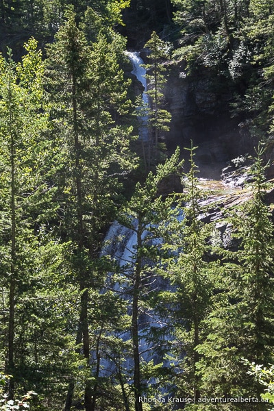
The next point of interest on Crypt Lake Trail is a waterfall viewpoint that’s just a few steps off the main path (watch for a side trail on the right hand side about 3.5 km into the hike). It’s not the greatest viewpoint since trees partially obstruct the view of Twin Falls, but it’s a nice place to sit and rest nonetheless.
.jpg)
After the waterfall the trail crosses over a small stream then continues up-valley through the forest.
.jpg)
.jpg)
Once you finally reach the fringe of the forest there are wonderful views of the peaks and valley, especially when looking back at where you just hiked.
.jpg)
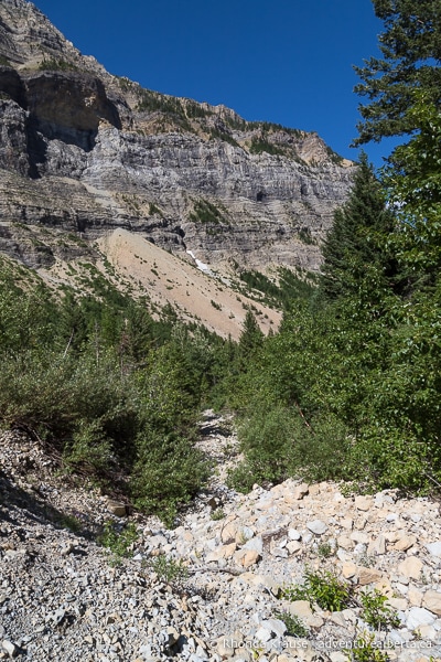
Now the trail gets rockier and steeper as it carries on into more open country for the scenic second half of the hike.
Soon you will be greeted with a wonderful view of Burnt Rock Falls dropping over a cliff of limestone and red argillite. As you make your way up a series of switchbacks you’ll be able to admire the falls from several different vantage points.
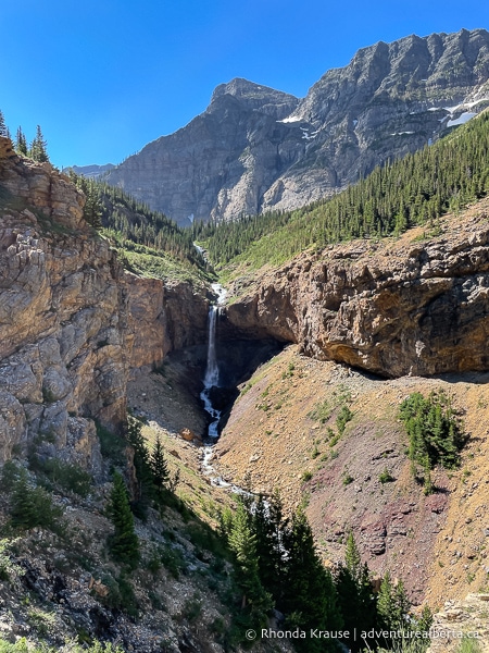
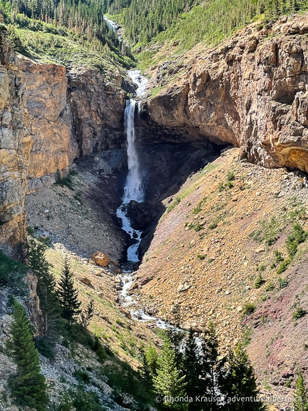
Beyond Burnt Rock Falls there are more switchbacks as the trail steeply climbs across rock covered slopes. For the duration of the climb there is a fantastic vista of mountains with Crypt Falls at the end of the valley. Above the falls hidden from view is Crypt Lake, the final destination of this hike.
.jpg)
.jpg)
As you advance further along the trail to higher ground you’ll also be able to see a small tarn near the bottom of Crypt Falls.
.jpg)
.jpg)
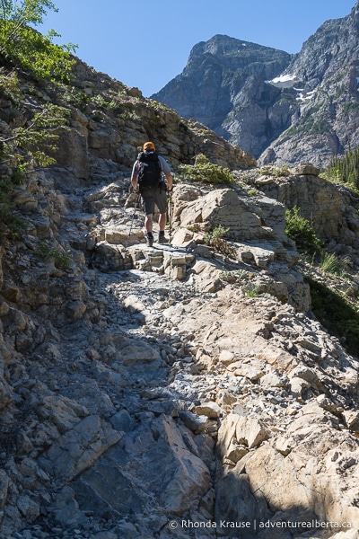
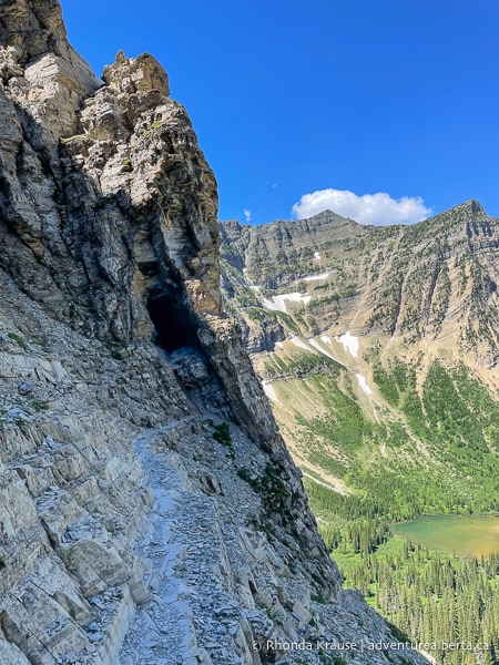
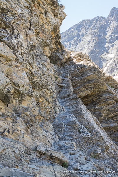
After making it across the talus slopes and conquering the final switchback, you’ll be closer to the wall of rock where the natural tunnel is. You can’t quite see the tunnel’s entrance yet, but it’s in the mountain spur on the right side.
.jpg)
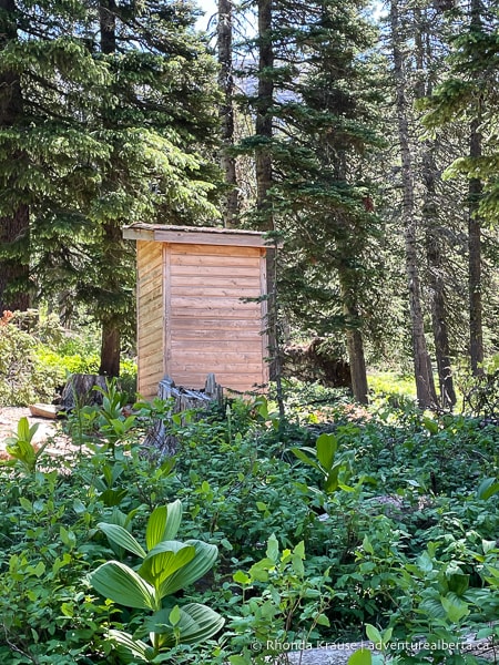
Before reaching the approach to the tunnel, the trail goes through a small area of trees. There’s an outhouse here if you need to use it.
Upon exiting the trees you have to cross a shallow creek. There’s some rocks you can use as stepping stones if you don’t want to get your feet wet.
.jpg)
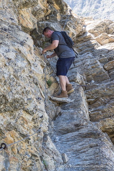
On the other side of the creek begins the most famous part of the Crypt Lake hike- the cliff traverse, ladder, tunnel, and cable section. You can typically expect a “traffic jam” of hikers here, since this section requires a slower pace and has no room for passing.
.jpg)
First up, the trail makes its way across a rocky slope below a towering wall of rock. From here there’s a beautiful view of Mount Boswell and the valley you just hiked through.
.jpg)
.jpg)
As you get closer to the tunnel the path gets narrower. There’s also some loose rock chips so you have to be extra careful with your footing. A slip and fall could send you tumbling down the steep, rocky mountainside.
After traversing the cliff you’ll reach the dark hole in the mountain. Climb the ladder that’s anchored to the rock to get inside the tunnel.
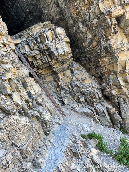
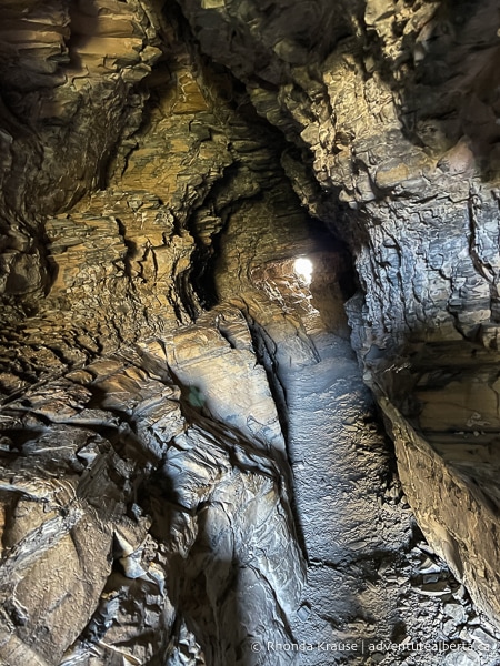
The tunnel is quite narrow and low in places so you’ll have to crouch down to walk through it. The tunnel is also longer than you might expect, at about 20 m.
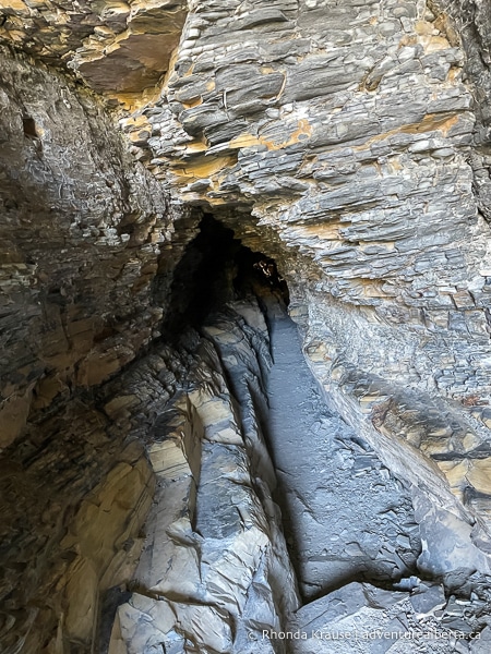
When you emerge from the tunnel you’ll have to step down using some rocks.
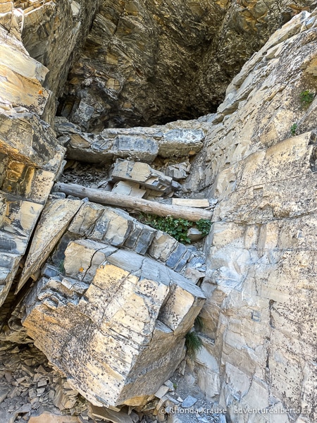
Proceed beside the wall of rock towards the waterfall. Turning a corner, the cable section comes into view.
.jpg)
For some people this is the most intimidating part of the hike because it involves a steep ascent along a rocky ledge. There is a cable bolted into the mountain for support, but you still should pay full attention to your foot placement. The path does widen soon after you start climbing, but closer to the top it tapers in one or two places.
.jpg)
Once you reach the top of the cable section it’s not far to Crypt Lake. The trail goes past a wall of rock and then turns to go up it, making a U-shape.
.jpg)
.jpg)
After you get over the rock, follow the trail through the trees and down towards the lake.
Crypt Lake sits in a glacially-carved cirque and is surrounded by 600 m tall cliffs. The water is very cold and even in the middle of summer you’ll likely see ice floating on its surface.
.jpg)
Most people stop and eat lunch at the entrance to the lake, but if you want to get away from the crowd follow the trail down the shoreline to the end of the lake, which actually sits on the Canada-USA border.
While the lake is a beautiful place to relax, make sure you keep an eye on the clock so you leave enough time to get back to the trailhead before the last shuttle leaves.
.jpg)
Once you’re rested and refueled, head back on the same trail as before and enjoy the spectacular valley views on your way down!
.jpg)
Review of the Crypt Lake Hike
The Crypt Lake hike is a trail that you’ll find varying opinions about- some people really love it, some think it’s hyped up more than it deserves, some find it scary and intimidating, whereas others find it more fun than thrilling.
How one feels about Crypt Lake Trail is closely related to their past hiking experience. People who are uncomfortable with heights and narrow spaces will likely find this hike challenging at times. Some people do turn around at the cliff walks before and after the tunnel and that is absolutely the best thing to do if you’re having doubts.
.jpg)
.jpg)
Hikers who aren’t afraid of heights, have a higher tolerance for risk, and who have tackled more dramatic and exhilarating routes such as the Angels Landing Hike in Zion National Park, may not find this trail to be exceptionally exciting. If you’ve done the Mount Norquay via ferrata (or another similar course) then the ladder and cable section won’t be a novel experience for you.
.jpg)
Depending on your perspective, the good news/bad news is that the “thrilling” section of the Crypt Lake hike is really short- only a couple hundred metres. You might be glad it’s over so quickly, or be left wanting more since there’s so much build up to it. The cable and tunnel section is pretty much the hike’s whole identity, which is why it can be somewhat of a let down if you were expecting a longer distance/higher number of adventurous points on the trail.
.jpg)
As for the rest of Crypt Lake Trail, there are gorgeous views of the valley and surrounding mountains once you exit the forest, but the scenery never really changes until the end of the hike when you reach Crypt Lake. And since it’s an out and back trail, the view is the same on the return hike.
.jpg)
Overall, the Crypt Lake hike is enjoyable, despite being a long slog to the fun features and best views. Even though it has less scenic variety than other hiking trails in Waterton Lakes National Park, it still is very beautiful and the most unique hike you can do in Waterton.
.jpg)
Tips for Hiking Crypt Lake Trail
Location: Crypt Lake Trail is in Waterton Lakes National Park, on the east side of Upper Waterton Lake. Waterton is approximately 270 km south of Calgary.
Getting to the Crypt Lake Trailhead: To get to the Crypt Lake trailhead you have to take a shuttle boat from the Waterton marina to Crypt Landing. Boats operate daily from June to October. There are two morning departures and two afternoon pickups from Crypt Landing during the peak summer tourist season (late June to early September). The current schedule and prices for the Crypt Lake ferry can be found here.
- Tickets and seats for the shuttle boat are first come, first served. Tickets can only be bought in person at the Waterton Shoreline Cruise office at the marina up to 3 days in advance of your hike. Tickets are sold the morning of departure, if available.
Best Time to Hike Crypt Lake Trail: The Crypt Lake hike is best done in the summer. The trail can only be accessed from June to October, as per the shuttle boat schedule.
Facilities: There is an outhouse at Crypt Landing and another one on the trail just before the approach to the tunnel.
Visitor Guidelines and Safety: This hike is not recommended for people who are scared of heights or claustrophobic. It’s also not recommended for children or dogs.
- The trail is in bear country so bring bear spray and know how to use it.
- The last half of the hike doesn’t have any shade so wear sun protection and take breaks as needed. There have been cases of heat exhaustion on this hike.
- Weather changes quickly in the mountains so come prepared with layers and rain gear.
- Leave no trace by packing out your garbage.
Gear and What to Bring: Wear hiking boots with a sturdy sole and good grips. Hiking poles are nice to have, especially if your knees get sore.
- Bring plenty of water, snacks, and a lunch to enjoy at the lake.
- You may also want to bring a bathing suit so you can take a swim after your hike while waiting for the shuttle boat.
.jpg)
Accommodations in Waterton Lakes National Park
For your convenience, here is a list of hotels in Waterton Lakes National Park. Please consider booking your Waterton accommodations through the included link. It costs nothing extra and helps support this website. Thank you!
Nearby Hikes and Places to Visit
You may also enjoy visiting these nearby trails and recreation areas:
Shop for Alberta & Adventure Themed Merchandise
.jpg)
.jpg)
.jpg)
Visit our store for more Alberta, nature, and adventure inspired products.


