
Purchases made through links earn us a small commission, at no extra cost to you.
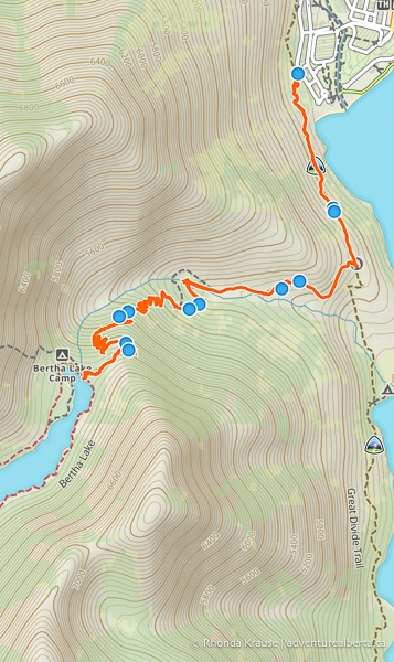
Bertha Lake Trail offers hikers the opportunity to see some fantastic scenery without venturing too far from the Waterton townsite. There are several points of interest on the Bertha Lake hike starting with a lookout point over Upper Waterton Lake, then the small but pretty Lower Bertha Falls, and finally Bertha Lake at the end of a switchbacking climb.
.jpg)
Bertha Lake Hike
Distance: 11 km round trip
Difficulty: Moderate
Elevation Gain: 458 m
Surface: Dirt with exposed rocks
Trail Type: Out and back
Time: 4- 5 hrs (including breaks and lunch at the lake)
Trailhead: The parking lot just off Evergreen Avenue, beside the campground and about 350 metres south of Cameron Falls.
Bertha Lake Trail Description
The Bertha Lake hike starts from the southwest end of town across from the campground. The trailhead has a small parking lot and a sign with a map and some information for trail users.
The trail begins with a gentle ascent through a forested area lush with trees and shrubs. A short while later, the view opens up revealing glimpses of Upper Waterton Lake and Vimy Peak beyond the water.
.jpg)
.jpg)
As the trail continues its gradual climb across the slope beside Upper Waterton Lake, the trees become more sparse and bare in places that were touched by wildfire. In these clearings, you may see wildflowers like fireweed (depending on the season) and get views of the surrounding peaks and the lake to your left.
.jpg)
.jpg)
.jpg)
One of the nicest areas of this section of the Bertha Lake hike is where the path runs along the edge of the slope because there are wonderful views of Upper Waterton Lake. Looking back you can also see the townsite and its stretch of beach.
.jpg)
.jpg)
Continuing on, you’ll cross over a rocky section of trail and pass by some more flowers in the forest as the path leads to a viewpoint overlooking Upper Waterton Lake.
.jpg)
.jpg)
.jpg)
At the viewpoint, there is a bench where you can sit and rest while admiring the mountain-framed lake. The bare tree branches allow for a less obstructed view of the surrounding scenery.
.jpg)
.jpg)
.jpg)
After leaving the lookout point the trail curves west. Soon after you’ll come to a signed junction. Keep straight to hike towards Bertha Falls and Bertha Lake, about 1.4 km and 4.2 km away respectively.
.jpg)
Beyond the junction the trail curves and heads southwest. This part of Bertha Lake Trail is quite beautiful since there are so many great views of Upper Waterton Lake as the path proceeds below a rocky peak. Like earlier, there are great photo opportunities when the trail gets closer to the slope’s edge.
.jpg)
.jpg)
.jpg)
Further ahead the trail turns and meanders west towards Lower Bertha Falls. There are lovely mountain views to your left and straight ahead as you pass through an open forest.
.jpg)
.jpg)
As you continue eventually you’ll be able to see the creek from the trail. This is a sign that you’re getting closer to the waterfall.
.jpg)
Once you see a bench and a footbridge crossing over the creek you’ll know you’ve arrived at Lower Bertha Falls.
.jpg)
From the bridge, you get a good view of the waterfall tumbling down a rock wall between the trees and then turning to flow under the bridge.

For a different vantage point, take the side trail across from the front of the waterfall. From here you can better see the fan shape of the waterfall and its veil of water cascading over tiers of rock.
.jpg)
A lot of people choose to end their hike here, but if you want to continue hiking to Bertha Lake cross the bridge. You’ll see a sign indicating that Bertha Lake is 2.8 km away with an elevation gain of 325 m. This last section of Bertha Lake Trail is more challenging because it’s where most of the elevation gain on this hike happens.
.jpg)
The trail starts ascending through the forest then passes through an area with dense vegetation on both sides of the path. The mountain views are especially nice here where there are fewer trees.
.jpg)
After this open area, the trail continues to climb through the forest. Ahead there are a series of switchbacks that help make the elevation gain less strenuous.

.jpg)
Just before another set of switchbacks, you’ll get a partial view of Upper Bertha Falls. Its drop is much longer and steeper than the lower waterfall, but there’s not a proper viewpoint from which you can look at the falls.

As you continue zigzagging up Bertha Lake Trail there are some points where you can see the Waterton lakes through gaps in the trees.
.jpg)
About 5.3 km into the hike the trail reaches its peak elevation then makes a short descent towards the north shore of Bertha Lake. On the way, you can see a long waterfall flowing down the mountain straight ahead.

Once you arrive at the lake there are a couple of small spots among the trees where you can admire the scenery. The lake is framed by peaks and cliffs and the water is clear enough to see rocks on its bottom.
.jpg)
While the view from the north shore is fantastic, there’s a larger, more comfortable beach to sit and rest on the west shore near the campsite, pretty much directly across from this spot.
.jpg)
.jpg)
To get there, follow the lakeshore trail a short distance to the bridge that crosses over the creek flowing out of the lake (another good photo spot!)
.jpg)
.jpg)
.jpg)
On the other side of the bridge, keep following the trail around the northwest part of the lake. Pass the campground and stay on the trail until you reach a junction. Keep straight towards the lake and you’ll come to the beach.

.jpg)
This little beach is a nice place to have lunch before either hiking around the lake (a little less than 4 km from this point) or returning to the Waterton townsite the same way you hiked in.
.jpg)
The return hike to Waterton is easygoing because it’s pretty much all downhill. The scenery is just as beautiful on the way back with views of Upper Waterton Lake, the creek down in the valley, and eventually the townsite with the Prince of Wales Hotel.
.jpg)
.jpg)
.jpg)
Review of the Bertha Lake Hike
The journey along Bertha Lake Trail is one of the most enjoyable hikes in Waterton Lakes National Park.
It’s full of wonderful scenery from waterfalls, mountains, and lakes to forests, wildflowers, and a creek. While Bertha Lake and Bertha Falls are definitely the highlight, the views of Upper Waterton Lake are memorable as well.
.jpg)
The Bertha Lake hike is a great choice if you want to do a moderately difficult trail, but if you change your mind there’s always the option to go only as far as Lower Bertha Falls and still have a satisfying hike.
.jpg)
Pictures of the Bertha Lake Hike
Here are a few more photos of Bertha Lake Trail.
.jpg)
.jpg)
.jpg)
.jpg)
.jpg)
.jpg)

.jpg)
.jpg)
.jpg)
.jpg)
.jpg)
Tips for Hiking Bertha Lake Trail
Location: Bertha Lake Trail is located at the southwest end of the Waterton townsite. The trailhead is just off Evergreen Avenue, beside the campground and about 350 metres south of Cameron Falls.
Getting to the Bertha Lake Trailhead: If you’re staying at the campground in town it’s a short walk to the trailhead, just cross Evergreen Avenue. If you’re staying at one of the hotels and want to drive, get onto Evergreen Avenue and follow it past Cameron Falls to the trailhead parking lot across from the campground.
Best Time to Hike Bertha Lake Trail: The Bertha Lake hike is best done in the summer (July and August) and early fall. The trailhead is in an avalanche path so check the Bertha-Townsite avalanche advisory before heading out (it’s updated daily).
Facilities: There are no toilet facilities at the trailhead (the closest would be in the campground). The backcountry campground at Bertha Lake has an outhouse.
Visitor Guidelines and Safety: This trail is in bear country so bring bear spray and know how to use it.
- Leave no trace by packing out your garbage.
Gear and What to Bring: Wear hiking boots with a sturdy sole. Hiking poles are nice to have, especially if your knees get sore.
- Bring plenty of water, snacks, and a lunch to enjoy at the lake.
.jpg)
Accommodations in Waterton Lakes National Park
For your convenience, here is a list of hotels in WATERTON LAKES NATIONAL PARK. Please consider booking your Waterton accommodations through the included link. It costs nothing extra and helps support this website. Thank you!
Nearby Hikes and Places to Visit
You may also enjoy these nearby trails and recreation areas:


