
Purchases made through links earn us a small commission, at no extra cost to you.
Blakiston Falls Trail is a short, easy hike to a pair of viewpoints that look down on a waterfall dropping into a mountain-framed canyon.
.jpg)
After a brief ascent through the forest, the trail emerges above Blakiston Creek flowing through a gorge then makes its way upstream towards Blakiston Falls. The falls are named after Lieutenant Thomas Blakiston, one of the first European explorers to the Waterton area.
.jpg)
The waterfall’s accessibility and scenic surroundings make Blakiston Falls Trail a worthy side trip from the nearby Red Rock Canyon.
.jpg)
Blakiston Falls Hike
Distance: 2.3 km round trip
Difficulty: Easy
Elevation Gain: 28 m
Surface: Packed dirt
Trail Type: Out and back
Time: 45- 60 minutes
Trailhead: The Red Rock Canyon upper parking lot.
.jpg)
Blakiston Falls Trail Description
The Blakiston Falls hike begins from the parking lot beside Red Rock Canyon. Since the canyon is one of the most popular attractions in Waterton Lakes National Park, it’s best to get there early in the morning or late afternoon so you can get a parking spot.
From the parking lot, cross the bridge over Red Rock Canyon then turn left at the trail junction. Here you’ll see a sign listing hikes that depart from this spot and their distances.
.jpg)
A few steps from the trailhead you’ll pass another sign with directions and distances to Blakiston Falls (1 km) and Blakiston Valley (10 km).
.jpg)
.jpg)
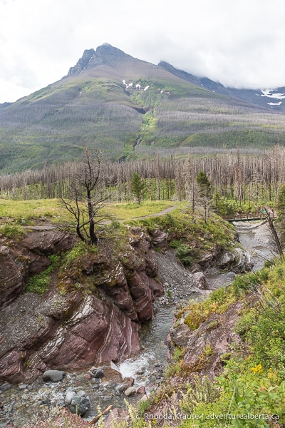
Follow the trail beside Red Rock Creek as it heads towards the mountains. The closest, most prominent mountain is Mount Blakiston and in the distance you can see Mount Hawkins.
.jpg)
.jpg)
Soon you’ll come to another bridge crossing Red Rock Creek. This links the path on the other side of the canyon to the main Blakiston Falls Trail, creating a loop around Red Rock Canyon. Don’t cross this bridge unless you want to go back to the parking lot.
.jpg)
Keeping straight on the trail, you’ll walk across a wooden bridge over Bauerman Creek. From here there are nice views of Anderson Peak. At the end of the bridge, the trail immediately turns right and heads into the forest.
.jpg)
.jpg)
As you hike through the lodgepole pine forest you’ll notice damage from the 2017 Kenow Wildfire, but also plenty of new vegetation that has sprung up among the dead trees. The bare tree branches allow for less obstructed views of Anderson Peak and the other mountains surrounding Blakiston Falls Trail.
.jpg)
.jpg)
.jpg)
.jpg)
As the path winds through the forest, it gains a bit of elevation until arriving at the edge of the canyon. This is where you’ll get your first glimpse of Blakiston Falls. The view of Mount Blakiston is pretty impressive too.
.jpg)
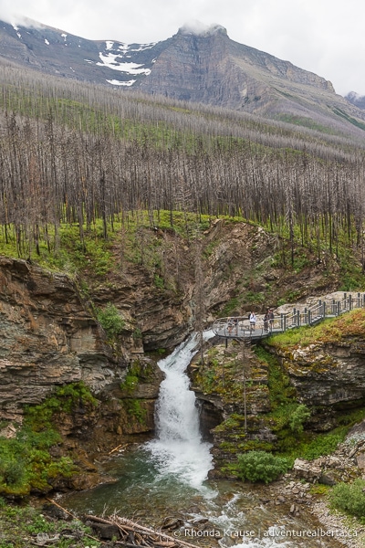
Next up, follow the trail along the top of the canyon towards the waterfall. It won’t be long until you arrive at a boardwalk that leads to some metal viewing platforms extending out over the gorge.
.jpg)
.jpg)
At the first viewing deck, you get a great view of Blakiston Falls and its backdrop of rocky peaks, including Mount Hawkins. Even though it’s not the closest viewpoint to the falls, the wide view it offers of the valley is quite remarkable.
.jpg)
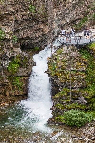
The second viewing deck is right beside the waterfall, so it gives a better impression of the water’s power as it tumbles into the canyon. From this viewpoint, you can also look upstream and see Blakiston Creek flowing down rocky steps toward the brink of the falls.
.jpg)
.jpg)
.jpg)
Once you’re finished admiring the waterfall, head back on the same trail you hiked in on. Before you re-enter the forest, there will be some nice views of Blakiston Creek flowing along the valley floor.
.jpg)
Review of the Blakiston Falls Hike
The Blakiston Falls hike is one of the best short hikes in Waterton Lakes National Park. Not only is there a big scenic reward for little effort, but the trail has a surprising amount of features for its length.
.jpg)
In just a 1 km stretch of trail, you can see a canyon, three creeks, a forest regenerating after a wildfire, a waterfall, and several mountain peaks. With so much scenic variety, Blakiston Falls Trail has something to offer everyone and is enjoyable for both casual explorers and experienced hikers.
.jpg)
.jpg)
.jpg)
Tips for Hiking Blakiston Falls Trail
Location: Blakiston Falls Trail is in Waterton Lakes National Park, at the end of the Red Rock Parkway.
Getting to the Blakiston Falls Trailhead: From the village of Waterton, take Highway 5 (the entrance road into the park) to the Red Rock Parkway. Follow the Red Rock Parkway to its terminus at the Red Rock Canyon parking lot.
Best Time to Hike Blakiston Falls Trail: The Red Rock Parkway is closed to vehicles in the winter, so this hike can only be done from early May (approximately) until the end of October. You can confirm seasonal road information with Parks Canada here.
Facilities: There are washrooms by the parking lot at the trailhead.
Visitor Guidelines and Safety: This trail is in bear country so bring bear spray and know how to use it.
- Leave no trace by packing out your garbage.
Gear and What to Bring: This hike can be done without any special gear. Regular running shoes are fine and hiking poles aren’t necessary.
- Bring water and maybe a small snack to enjoy at the viewpoints (there are benches).
.jpg)
Accommodations in Waterton Lakes National Park
For your convenience, here is a list of hotels in Waterton Lakes National Park. Please consider booking your Waterton accommodations through the included link. It costs nothing extra and helps support this website. Thank you!
Nearby Hikes and Places to Visit
You may also enjoy these nearby trails and recreation areas:
Shop for Alberta & Adventure Themed Merchandise
.jpg)
.jpg)
.jpg)
Visit our store for more Alberta, nature, and adventure inspired products.


