
Purchases made through links earn us a small commission, at no extra cost to you.
The Carthew-Alderson Trail has a reputation for being one of the most beautiful hikes in Waterton Lakes National Park. On this long day hike, the trail passes through various picturesque landscapes including subalpine forests and meadows, argillite scree slopes, a high ridge, and a pair of lakes nestled in a mountain-framed valley.

Since the Carthew-Alderson hike is a point to point trail, starting at Cameron Lake and ending in the town of Waterton, two vehicles are required for transportation to and from the trailheads, or you can buy a ticket for the hiker shuttle to Cameron Lake and then walk back to your accommodations in town.

Carthew-Alderson Hike
Distance: 19.5 km
Difficulty: Strenuous (for the first half of the hike and because of the length)
Elevation Gain: 725 m
Surface: Dirt and rock
Trail Type: Point to point
Time: 7- 8 hours
Trailhead: Cameron Lake. You could also start at the other end of the trail in town by Cameron Falls, but this would make the hike steeper (the townsite is about 365 m lower than Cameron Lake).

Carthew-Alderson Trail Description
Most people start hiking Carthew-Alderson Trail from Cameron Lake since there’s a commercial shuttle bus that transports hikers to this trailhead. The driver will drop you off at the sidewalk that leads to the lake. To find the trailhead, turn left at the boat rental building. On GPS apps, the trail you want to follow is labelled the “Great Divide Trail”.

To start off, you will be walking along a regular sidewalk. You’ll soon come to a wood bridge crossing Cameron Creek where you can get a nice view of Cameron Lake.


After the bridge, the sidewalk ends and the path turns to follow along the lakeshore. There’s also a sign giving distances to points of interest along Carthew-Alderson Trail.


During the first segment of this hike, the trail ascends into the forest beside Cameron Lake, becoming steeper after the first switchback. The vegetation is quite lush at first, but later the trail passes through an area affected by the 2017 Kenow Wildfire.


Now that the trail has gained some elevation, there are decent views of Cameron Lake and its surrounding mountains. Before the fire the views would have been more obstructed.


As the trail continues uphill through the forest you’ll see a lot of shrubs and perhaps some wildflowers, depending on the time of year. There are also more views of the mountains and Cameron Lake to enjoy.


At the top of the switchbacks the trail levels out for an easy walk through an open forest. Here you’ll see plenty of dead, charred trees and distant mountain peaks.


This part of the trail is also a good opportunity to see wildflowers, including creamy white bear grass which only blooms every 5-7 years.


Following the trail, the next notable landmark you’ll come to is a large red rock wedged between a group of dead trees.

Ahead the trail makes a descent and Summit Lake comes into view between gaps in the trees. Soon you’ll arrive at a signed junction and a short path that leads to the lakeshore. This is a good place to rest before the upcoming ascent.


Once you’re ready to continue hiking Carthew-Alderson Trail, head north from Summit Lake. The trail sign indicates that it’s 3.6 km to Carthew Summit, the highest point on this hike.

The next segment of trail makes a lengthy, gradual ascent through more open forest. You’ll be able to see some peaks, but as you gain elevation more of the mountains will be revealed.


Once you get higher up, it’s worth stopping every so often to enjoy the surrounding mountain views. Don’t forget to look back, because the scenery is especially pretty in this direction.


Keep following the path until the barren ridge of Carthew Summit comes into full view. That is where you’ll be heading next via a trail that runs below Buchanan Ridge.


The path now heads north toward Buchanan Ridge. A word of caution- even in late July there can be a significant amount of snow at this part of the hike.

If snow is overhanging from the small hill beside the trail (a cornice), it’s best to make a wide detour staying above the snow line, then descend to rejoin the trail once you get beyond the snow.


Now begins the long journey across the slope of Buchannan Ridge toward Carthew Summit. First, you’ll pass through an area with some dead trees and exposed rocks. Watch for marmots as they sometimes hang out here.


Further ahead there are fewer trees and the trail crosses a scree-covered slope of red argillite. There’s no shade from the heat of the sun, but the views are wonderful, especially of the small turquoise lake in the distance.


Next, the trail switchbacks up a rocky slope between two peaks on the ridge. Extra paths have been created by people shortcutting up the hill, but it’s best to stay on the switchbacks to prevent unnecessary erosion. You’ll notice yellow/orange posts marking the correct trail.

Again, it’s worth it to stop once in a while during the ascent to appreciate the diverse alpine scenery.


At the top of the switchbacks, you’ll have reached Carthew Summit/Carthew Ridge, the highest point on the Carthew-Alderson hike. From here you can enjoy 360-degree views of peaks in Waterton Lakes National Park and the nearby Glacier National Park.


It can be really windy on the ridge, so most hikers continue down to the Carthew Lakes before stopping for a lunch break.
Follow the trail that goes left along the ridge (watch for markers) and soon you’ll get a nice view of the Carthew Lakes framed by multi-coloured mountains. Way off in the background you can see the prairies.


The rest of the hike is literally all downhill from here, so although it’s long, it’s not difficult as the elevation gain is behind you.
Keep on the trail as it descends toward the Carthew Lakes. On a hike with so many pretty views, this is one of the best.


At the first Carthew Lake, the trail proceeds across a grassy area then along the far shoreline. As you hike along the shore you can see different shades of blue in the lake.


At the end of the first lake, the trail passes through an area with grass, short trees, shrubs, and rocks. You’ll also pass a small waterfall and stream linking the Carthew Lakes.


If you haven’t seen a marmot on the hike yet, this part of the trail could be another opportunity as they like to hang out in rocky areas.

Continue following the path toward the second Carthew Lake. Soon you’ll come to another waterfall beside the trail. At this point, it’s a little confusing where to go because there’s an obvious trail that crosses in front of the waterfall, but also a less obvious path on the left going down toward the lake.


If you’re following a GPS hiking app, it’ll show the trail veering left toward the lake. If you end up keeping straight at the waterfall, you can still make your way down to the lake.
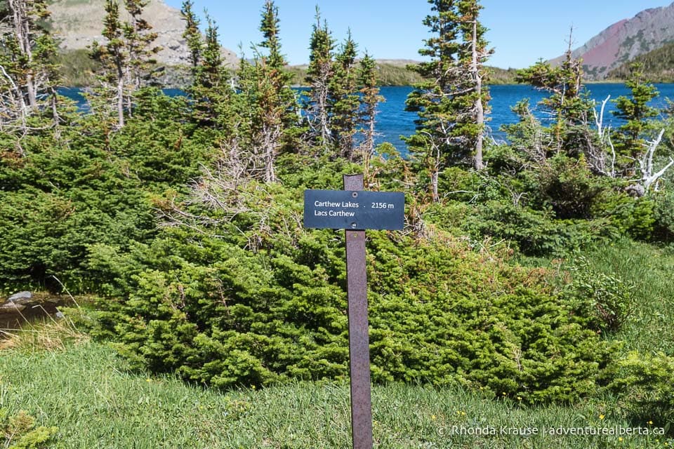
Heading left to stay on track, you’ll go downhill through an area of trees before reaching the second Carthew Lake. Here there’s a junction with the Mount Alderson Route and a sign welcoming you to the Carthew Lakes at 2156 m elevation.


At the junction, turn left to stay on the Great Divide Trail that hugs the shore of the lake.


After walking down the shoreline, the path passes through a small area of trees and comes to a clearing with mountain views.


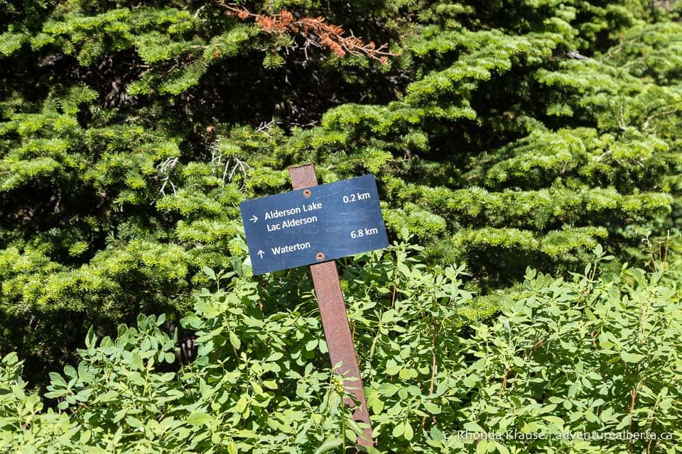
From this spot look right to see a gorgeous view of Alderson Lake, the next destination on this hike.

Follow the steep, rocky trail downhill. It will make a sharp turn then Alderson Lake comes into view in the distance.


The trail continues downhill into the valley and eventually comes to a towering waterfall splashing down a wall of rock. Its height is quite impressive!


Beyond the waterfall, the path keeps going towards Alderson Lake at the foot of Mount Alderson. Closer to the lake the trail swings left and descends to an alpine meadow with more fantastic mountain views.


After the meadow the trail heads into the forest, offering a final elevated view of Alderson Lake before moving into a denser area of trees.

As the trail descends through the treed valley, you’ll have a nice view of a mountain straight ahead. It won’t be long until you arrive at a marked side trail that goes to the backcountry campground at Alderson Lake, if you want to detour for a closer look at the water.


Keep straight to make your way back to the Waterton townsite. This last segment of the Carthew-Alderson hike is a long walk in the forest, but occasionally there are good views of mountains on the way.


At some points along this stretch of Carthew-Alderson Trail, the vegetation has really crowded the path. While you don’t have to “bushwhack” to find your way, it can be uncomfortable to have plants rubbing against your arms and legs.

Eventually, the trail once again passes through a part of the forest that was burned by wildfire. A lot of new plant life has sprouted up bringing colour to the landscape.

Nearing the end of the hike, Akamina Parkway comes into view, and later so does Upper and Middle Waterton Lake and the townsite.


Once you reach the part of the trail with a fence blocking people from going down to Cameron Creek you’ll know the hike is almost over.

After one last set of descending switchbacks, you’ll arrive at Cameron Falls at the edge of town. From here it’s a short walk to the townsite campground and hotels.

Review of the Carthew-Alderson Hike
Carthew-Alderson Trail is definitely deserving of the high praise it receives, so it’s easy to see why it’s a favourite hike of Waterton locals.

There’s so much scenic variety to keep things interesting during a long day, including lakes, waterfalls, forests, wildflowers, mountains, and colourful rocks. The trail’s diversity makes it far more visually rewarding than the famous Crypt Lake hike.

Another nice thing about the Carthew-Alderson hike is that the trail is not as busy as others in the park. You’ll mainly see people at the summit and Carthew Lakes, but the trail is not crowded so you should be able to experience some solitude on this hike.

Pictures of the Carthew-Alderson Hike
Here are some more photos taken while hiking Carthew-Alderson Trail.


Tips for Hiking Carthew-Alderson Trail
Location: Carthew-Alderson Trail is in Waterton Lakes National Park. The trail links Cameron Lake with the town of Waterton.
Getting to the Carthew-Alderson Trailhead: The most convenient way to get to the Carthew-Alderson trailhead at Cameron Lake is to take the hiker shuttle operated by Tamarak Outdoors. This way you don’t need to have two vehicles- one left at end of the trail in town and another to get to the Cameron Lake trailhead.
Carthew-Alderson Trail Shuttle: The hiker shuttle to the Carthew-Alderson trailhead (called the Cameron Express) operates daily during the hiking season. Tickets for the shuttle can be booked in advance online or in person at Tamarak Outdoors. Many people buy tickets on the morning of their hike, but if you don’t have flexibility on dates you may want to book ahead to avoid disappointment.
- Prices, departure times, and tickets can be found here.
- The shuttle is pet friendly.
Best Time to Hike Carthew-Alderson Trail: The Carthew-Alderson hike is best done in the summer. Due to the trail’s high elevation, there can still be some areas of snow in July.
Facilities: There are outhouses by the Cameron Lake parking lot, at the Alderson Lake backcountry campground, and across from Cameron Falls at the end of the trail.
Visitor Guidelines and Safety: This trail is in bear country so bring bear spray and know how to use it.
- There are lengthy sections without shade, so wear sun protection.
- Weather changes quickly in the mountains so come prepared with layers and rain gear.
- Leave no trace by packing out your garbage.
Gear and What to Bring: Wear hiking boots with sturdy soles and good grips. Hiking poles are nice to have.
- Bring plenty of water, snacks, and a lunch to enjoy at the lakes.

Accommodations in Waterton Lakes National Park
For your convenience, here is a list of hotels in Waterton Lakes National Park. Please consider booking your Waterton accommodations through the included link. It costs nothing extra and helps support this website. Thank you!
Nearby Hikes and Places to Visit
You may also enjoy these nearby trails and recreation areas:
Shop for Alberta & Adventure Themed Merchandise


Visit our store for more Alberta, nature, and adventure inspired products.