
Purchases made through links earn us a small commission, at no extra cost to you.
The Siffleur Falls hike is one of the top hikes in David Thompson Country because it offers beautiful views for minimal effort.
With a suspension bridge, two river crossings, a boardwalk passing over a pretty plain, a deep canyon, quiet forest, raging waterfall, and mountains all around, Siffleur Falls Trail has all the elements for a satisfying hike.
.jpg)
Siffleur Falls Hike
Distance: 7.1 km round trip
Difficulty: Easy
Elevation Gain: 101 m
Surface: Gravel, dirt, section of boardwalk
Trail Type: Out and Back
Time: 2- 2.5 hours (including breaks at the viewpoints and falls)
Trailhead: Siffleur Falls Staging Area near the south end of Abraham Lake (just off Highway 11/David Thompson Highway)
.jpg)
Siffleur Falls Trail Description
The Siffleur Falls hike begins with a minor descent from the Siffleur Falls Staging Area into the Kootenay Plains Ecological Reserve. The wide, flat trail passes through an area of evergreen trees then soon opens up to a view of the North Saskatchewan River and surrounding mountains.
.jpg)
Along this first section of trail in the Kootenay Plains Ecological Reserve, there are interpretive panels providing information about the landscape, its history, and inhabitants. You can read about how glaciers and erosion formed the valley, the wildlife and plants that live on the Kootenay Plains, and the characteristics of the montane subregion the reserve protects.
.jpg)
After walking a short distance along the North Saskatchewan, you’ll cross the river over a long, narrow suspension bridge welcoming you to a scenic meadow.
.jpg)
Since the montane vegetation is so delicate, a boardwalk was built to create a raised trail for crossing it. The boardwalk winds across the plains and around conifer trees before ending at a trail leading into a backcountry area.
.jpg)
.jpg)
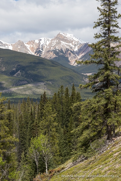
Continue straight down this wide, forested trail and enjoy views of the nicely framed mountain in the distance.
.jpg)
The trail eventually makes a turn and heads towards the second photogenic river crossing on the Siffleur Falls Trail.
.jpg)
.jpg)
After crossing the Siffleur River, the trail turns upstream and starts making its way through the forest. The dirt path has sections of protruding rocks and the view of the river is mostly lost behind trees.
.jpg)
Eventually the trail comes to a hill, climbing up to a forest of white spruce and lodgepole pine where it then levels out.
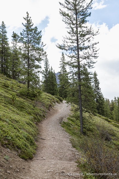
.jpg)
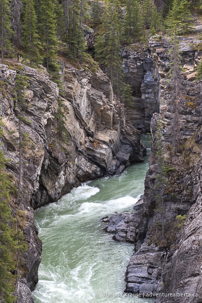
In the shade of the forest you can start to hear the roar of Siffleur Falls and soon the canyon walls appear through breaks in the trees. There are some side paths leading from the main trail to the canyon’s edge, but there is no safety barrier and the ground may not be stable so it’s best not to venture off track. There’s no need to either, since there are several safe viewpoints up ahead.
Keep a lookout on your right for the first fenced viewpoint along the canyon wall. Here you can look up and down the canyon and see the Siffleur River below.
.jpg)
.jpg)
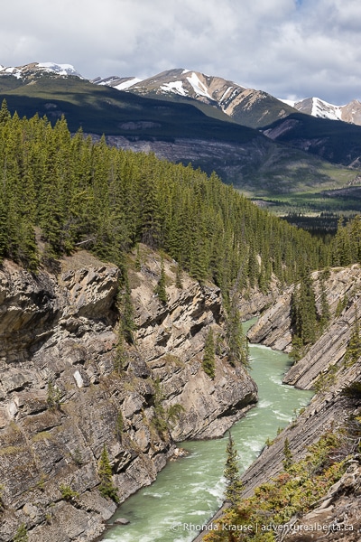
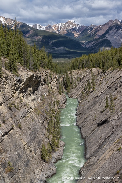
The next viewing area on the trail is a wooden platform where you can get an even better view of the Siffleur River flowing between the canyon’s rocky, sloped walls. It’s hard to believe that this stunning scene is not even the main attraction of this hike!
.jpg)
.jpg)
.jpg)
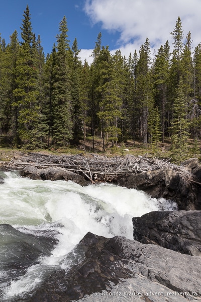
Continuing on, it’s not very far until you reach Siffleur Falls. The falls are formed by the Siffleur River plunging down through a narrow opening to the canyon.
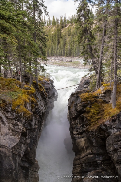
Here you’ll find two excellent places for viewing Siffleur Falls. The first is a platform that stands in front of the waterfall, close enough to feel a light, refreshing mist.
.jpg)
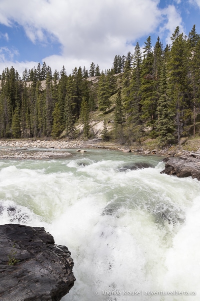
The second viewing area is at the top of the falls, where the river tumbles over a ledge and disappears into the canyon.
.jpg)
The viewing area at the brink of the falls is quite close to the water, but some people still find it tempting to crawl over the barrier just to get a tiny bit closer. It’s so important to keep a safe distance from the falls, river, and cliffs because there have been several casualties.
If you want to continue walking upstream there are two more waterfalls (approximately 2.5 km and 4 km from this first waterfall on Siffleur River), but most people choose to end their hike here.
.jpg)
.jpg)
To return to the trailhead, simply retrace your route on Siffleur Falls Trail back to the staging area.
Review of the Siffleur Falls Hike
The Siffleur Falls hike is a very enjoyable outing in David Thompson Country thanks to the low effort, high reward trail.
.jpg)
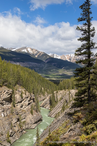
Beautiful views of the North Saskatchewan and Siffleur rivers, Kootenay Plains, and nearby Rocky Mountains give this hike much more to offer than just its namesake final destination.
.jpg)
While Siffleur Falls are definitely worth seeing, they are not as big and spectacular as the nearby Crescent Falls. However, the Siffleur Falls trail is more scenic than the Crescent Falls trail. A nice thing is that both hikes are short and easy enough that they can be done in one day, so you don’t have to choose between the two!
Pictures of Siffleur Falls Trail
Here are a few more pictures of the hike to Siffleur Falls.
.jpg)
.jpg)
.jpg)
.jpg)
.jpg)
Tips for Hiking Siffleur Falls Trail
Location: Siffleur Falls are located in Clearwater County in west central Alberta. The Siffleur Falls staging area is a large parking lot about 62 km southwest of Nordegg and 21 km east of Banff National Park on Highway 11, near the south end of Abraham Lake.
Getting to Siffleur Falls Trailhead: If coming from Edmonton or Red Deer, you will pass through Rocky Mountain House and take Highway 11 (the David Thompson Highway) directly to the trailhead.
- If coming from Calgary, take Highway 1 through Banff, continue past Lake Louise on the Icefields Parkway, then turn onto Highway 11 at Saskatchewan River Crossing. Follow this to the staging area.
Best Time to Hike Siffleur Falls Trail: The Siffleur Falls hike can be done year round but conditions are typically best between May and October.
- This is a heavily trafficked trail that is especially popular on weekends and in the summer. Hiking it mid-week in the spring or fall will avoid the crowds. The parking lot is medium sized and can fill up, so starting early is a good idea.
Facilities: There is an outhouse at the staging area.
Visitor Guidelines and Safety: Even though Siffleur Falls Trail is an easy hike, that’s not to say it’s without hazards. There have been fatal hiking accidents here so be sure to stay on the main trail, only approach the canyon at official viewpoints, and stay behind barriers.
- The trail is in bear country so bring bear spray, make noise while hiking, and educate yourself on what to do if you encounter one.
- There is no cell service so if you use a hiking app you will need to download an offline map ahead of time.
Gear and What to Bring: Regular running or walking shoes are fine but you’ll want something with a sturdy sole and closed toe since there are exposed rocks and roots on the trail.
- Bring water and some snacks to enjoy at the falls.
.jpg)
Nearby Hikes and Places to Visit
You may also enjoy these nearby trails and places to visit:
Shop for Siffleur Falls Merchandise
.jpg)
.jpg)
.jpg)
.jpg)
.jpg)
.jpg)
Visit our store for more Alberta, nature, and adventure inspired products.


