
Purchases made through links earn us a small commission, at no extra cost to you.
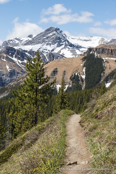
The Nordegg and Abraham Lake area is one of the best hiking destinations in Alberta. Not only is the area easily accessible from central Alberta, but the Nordegg hikes also showcase some of the province’s finest scenery.
.jpg)
When you go hiking near Nordegg, you’ll discover opportunities to summit mountains, get close to waterfalls, look down into rocky canyons, walk along scenic ridges, explore peaceful forests, picnic on the shores of backcountry lakes, and stroll through picturesque meadows.
.jpg)
No matter your interests or skill level, the Nordegg hikes offer something for everyone in every season.
Nordegg Hiking Guide- Nordegg Hikes vs Abraham Lake Hikes
The hamlet of Nordegg is the gateway to an impressive number of hikes along the David Thompson Highway, stretching from the foothills in the North Saskatchewan River valley to the eastern edge of the Rockies at the entrance to Banff National Park.
.jpg)
There are several hikes near Nordegg itself, but many of the area’s most impressive trails are located closer to the Rockies near Abraham Lake.
.jpg)
The hikes around Nordegg are great if you don’t want to drive as far from Central Alberta, but are still looking to enjoy some distant mountain views. If you want to be immersed in the Rockies and experience the dramatic views mountains offer, then the Abraham Lake hikes are recommended.
.jpg)
Hikes Near Nordegg- Trails to Explore on a Nordegg Hiking Trip
To help you plan your next Nordegg hiking trip, here are some trails you can access from the David Thompson Highway. Keep in mind that this is a small selection of all the possible hikes near Nordegg. This Nordegg hiking guide is a work in progress and will continue to grow as the Adventure Alberta team ventures out on more Nordegg hikes.
.jpg)
For organization, we’ve presented the hikes starting with trails that are closest to Nordegg, then moved west along the David Thompson Highway towards Banff National Park. We also made a map and plotted the staging area for each hike.
Coliseum Mountain
Hike Length: 14.2 km
Difficulty: Moderate
Distance from Nordegg: 0 km (Starts in Nordegg from the residential subdivision on the north side of Hwy 11)
Trail Guide: Coliseum Mountain Hike
Coliseum Mountain is the closest summit hike to Nordegg, but that’s not the only reason why it’s so popular. There’s a great reward to effort ratio, with only a moderate amount of exertion needed to summit the mountain’s round “cap” and see sweeping views of the forested foothills.
.jpg)
.jpg)
The first part of the hike is a lengthy walk in the forest as the trail switchbacks up the mountain. Once you get above the tree line, it’s an enjoyable walk along the curved spine of the mountain to the summit cap. During this section of trail, and at the summit, there’s a panoramic view of the wilderness surrounding Nordegg and the David Thompson Highway.
.jpg)
.jpg)
Crescent Falls
Hike Length: 4.9 km
Difficulty: Easy
Distance from Nordegg: 22 km
Trail Guide: Crescent Falls Hike
The hike to Crescent Falls isn’t mandatory to see the waterfall, since you can drive right to it, but the trail offers a fantastic view of the falls (and some peace and quiet) that you don’t get from the main observation area.
.jpg)
This hike follows a trail that runs along the top of Bighorn Canyon, between the Bighorn Canyon lookout and Crescent Falls. The first section offers some views of the canyon before heading into the forest. Closer to the waterfall, a short detour off the main path leads to a spectacular viewpoint where you can see both the upper and lower falls and their plunge pools. The hike ends at the Crescent Falls observation deck in Crescent Falls Provincial Recreation Area.
.jpg)
.jpg)
Allstones Lake
Hike Length: 8.1 km
Difficulty: Strenuous (with some moderate sections)
Distance from Nordegg: 31.5 km
Trail Guide: Allstones Lake Hike
The Allstones Lake hike offers some of the best variety in terms of scenery, showcasing forests, mountain peaks, and a lovely alpine lake. However, you really have to earn those views since there’s a steep, sustained climb for about the first ¾ of the hike.
.jpg)
.jpg)
After a hard, uphill hike through the forest, the trail arrives at a pair of red chairs where you can rest and admire Abraham Lake in the distance. The path then continues to climb before traversing across a slope where you get a wide view of the mountain range just across the valley. Next comes a downhill walk through the trees and soon you’ll arrive at a small campground next to Allstones Lake. There are several lovely spots along the lakeshore perfect for enjoying a picnic lunch.
.jpg)
.jpg)
Vision Quest
Hike Length: 4.7 km
Difficulty: Strenuous
Distance from Nordegg: 44 km
Trail Guide: Vision Quest Hike
Vision Quest is one of the best Nordegg hikes for views of Abraham Lake, but it’s also one of the most challenging hikes on the David Thompson Highway. This rocky trail climbs from beginning to end, gaining a lot of elevation in a short distance. The payoff is stunning views of Abraham Lake, Mount Michener, and other prominent peaks that can be seen throughout the majority of the hike.
.jpg)
.jpg)
The terrain on this hike is rough (covered in scree) and there’s not always one clearly defined trail, but rather several routes that all head to a false summit. Along the way you’ll pass through a site used for vision quests. At the end of the hike there’s an option to scramble up to the second summit, or you can simply enjoy the jaw-dropping scenery from the ridge.
.jpg)
.jpg)
Cline River Falls
Hike Length: 3.5 km
Difficulty: Easy
Distance from Nordegg: 49 km
Trail Guide: Cline River Falls Hike
If you’re looking for some hikes near Nordegg that can easily be done in the winter, add Cline River Falls to your list. This hike may be short, but it definitely doesn’t compromise on scenery.
.jpg)
With frozen waterfalls in a snow-dusted canyon and a vista of rocky mountain peaks, there are plenty of frosty views to enjoy on this winter hike. The trail starts with a mostly flat walk through the forest then arrives at a viewpoint above the Cline River Canyon. The path then makes an icy descent down to the canyon floor where you can stand at the base of a sprawling frozen waterfall.
.jpg)
.jpg)
Since this hike doesn’t take very long, you’ll have time afterwards to go admire the famous Abraham Lake ice bubbles.
Siffleur Falls
Hike Length: 7.1 km
Difficulty: Easy
Distance from Nordegg: 63 km
Trail Guide: Siffleur Falls Hike
Siffleur Falls is one of the most well known (and therefore popular) hikes near Nordegg. Scenery wise, it offers the best views for the least amount of effort, which makes the hike great for families.
.jpg)
After crossing the North Saskatchewan River via a suspension bridge, the trail passes over a meadow on a boardwalk then makes its way across the Siffleur River. A walk through the forest follows and soon you can hear Siffleur Falls plunging into the canyon. There are several fenced viewpoints where you can admire the canyon, river, and at the end of the hike, Siffleur Falls.
.jpg)
.jpg)
Kinglet Lake
Hike Length: 10.5 km
Difficulty: Strenuous
Distance from Nordegg: 66 km
Trail Guide: Kinglet Lake Hike
Kinglet Lake Trail has a variety of scenery to enjoy including valleys, mountains, forests, and hoodoos, but it’s no walk in the park to get to the clear lake and campground at the end of the trail.
After a moderate walk into an open forest, the trail begins climbing up to the top of a valley. The trail then passes through a meadow before starting a second steep climb above the valley at the edge of the forest. The trail pops in and out of the trees, eventually arriving at a beautiful lake overlooked by Whirlpool Ridge. Kinglet Lake is stocked with trout, so you may want to bring a fishing pole.
.jpg)
Review of the Nordegg Hikes
There are so many interesting hiking trails along the David Thompson Highway suitable for a range of skill levels. There are options for short strolls, half-day nature walks, full-day hikes, and overnight backpacking trips.
.jpg)
.jpg)
The scenery is beautiful and varied, especially on the hikes near Abraham Lake. The area really has it all- mountains, waterfalls, canyons, forests, plains, and lakes. On some hikes you may even spot hoodoos and find fossils.
.jpg)
Another bonus of hiking near Nordegg is that you don’t need to buy a park pass, like when you visit Banff and Jasper, because the area is not within the boundaries of a National Park.
One downside is that the area doesn’t have enough facilities, such as outhouses and garbage bins at all the trailheads. Unfortunately this lack of facilities, along with an increase in irresponsible visitors, has caused some environmental stress on the area. If you go hiking near Nordegg, please do your part to keep the landscape pristine.
.jpg)
.jpg)
If you’re looking for a hike with remarkable scenery that is close to central Alberta, you’ll find plenty that fit the bill around Nordegg and Abraham Lake. The area is a place you can return to over and over again and still discover exciting routes to explore. The impressive scenery and huge selection of trails makes Nordegg one of the best places to go hiking in Alberta!
.jpg)
Tips for Hiking Near Nordegg
Location: Nordegg is located in west central Alberta on the David Thompson Highway (Hwy 11) between Rocky Mountain House and Banff National Park.
Drive Times: The Nordegg townsite is approximately a 50 minute drive from Rocky Mountain House, 1 hr 45 min from Red Deer, 3 hours from Edmonton, and 3 hours from Calgary.
- For hikes that are past Nordegg and closer to Abraham Lake, expect to drive an additional 20-50 minutes, depending on the trail you choose.
Facilities and Services: Nordegg has gas stations, a café, snack bar, hotel, hostel, and a few other accommodation options. There are a lot of campgrounds along the David Thompson Highway.
- The David Thompson Resort is about halfway down Abraham Lake and has a restaurant, gas station, and accommodations. The resort is closed from October 1- March 31.
- A lot of the trailheads don’t have outhouses, but you can find some at the campgrounds and provincial recreation areas.
- Beyond Nordegg cell service is limited or non-existent.
Visitor Guidelines and Safety: The Nordegg hikes and Abraham Lake hikes are in bear country. Bring bear spray, make noise while hiking, and educate yourself on what to do if you encounter one.
- If you use a hiking app, download your trail maps ahead of time since much of the area doesn’t have cell service.
- A lot of the trails aren’t signed, so research your route in advance.
- Weather can change quickly in the mountains so come prepared with layers and rain gear.
- Leave no trace by packing out your garbage. If there are no bins at the trailhead, or they are full, take your garbage home with you.
.jpg)
Nearby Hikes and Places to Visit
You may also enjoy these nearby trails and places to visit:
Shop for Alberta & Adventure Themed Merchandise
.jpg)
.jpg)
.jpg)
.jpg)
.jpg)
.jpg)
Visit our store for more Alberta, nature, and adventure inspired products.


