
Purchases made through links earn us a small commission, at no extra cost to you.
With so many Lake Louise hikes to choose from, Devil’s Thumb Trail stands out for its dramatic, sweeping views of turquoise lakes, creaking glaciers, and rocky mountain peaks.
.jpg)
The Devil’s Thumb hike incorporates a scenic side trail with two of the most popular Lake Louise hikes to form one remarkable loop. The first segment of the hike is on Lake Agnes Trail, the second section follows Big Beehive Trail to the top of the Big Beehive, the third part proceeds on Devil’s Thumb Trail to the summit of Devil’s Thumb, and the final segment returns to Lake Louise via a portion of the Highline and Plain of Six Glaciers Trail.
.jpg)
This picturesque, challenging route is a full day hike that showcases some of the very best experiences that Lake Louise has to offer, from visiting a mountain tea house to admiring glacier-capped peaks. The highlight though is the expansive 3-in-1 view of Lake Louise, Lake Agnes, and Big Beehive that rewards those who summit Devil’s Thumb.
.jpg)
Devil’s Thumb Hike
Distance: 14.3 km round trip
Difficulty: Strenuous (with moderate sections)
Elevation Gain: 752 m
Surface: Mix of dirt and rock
Trail Type: Loop (as described here) but can be done as an out and back
Time: 7-8 hours (including breaks at the tea house, Big Beehive, and Devil’s Thumb)
Trailhead: In front of Chateau Lake Louise, along the lakeshore
.jpg)
Devil’s Thumb Hike Description
Part 1: Lake Louise to Lake Agnes (via Lake Agnes Trail)
The Devil’s Thumb hike starts a short distance away from the parking lot at Lake Louise. After following the path towards the chateau, you’ll see the first trail sign just after the bridge at the mouth of the creek.

You’ll notice the sign doesn’t say Devil’s Thumb, and the hike doesn’t appear on any Parks Canada maps either, so you’ll want to follow the signs to Big Beehive, as this is where there’s a junction with Devil’s Thumb Trail.
After briefly walking along the shoreline of Lake Louise you’ll make a slight right onto Lake Agnes Trail.
.jpg)
This section of the hike is straightforward and only moderately challenging as it makes a steady (but not steep) ascent through the forest. It also can be very busy, as the Lake Agnes Tea House hike is one of the most popular trails in Lake Louise.
.jpg)
Two kilometers in you’ll finally get your first semi-decent view of Lake Louise through a break in the trees. The trail then cuts right and continues uphill through the forest before arriving at Mirror Lake.
.jpg)
Here you can see Big Beehive looming above the lake and reflecting off its blue-green water, hence the name Mirror Lake.
.jpg)
After Mirror Lake the trail is still in the trees but the views start to open up, giving glimpses of the Big Beehive and surrounding mountains as you hike the last 0.8 km to the tea house.
.jpg)
.jpg)
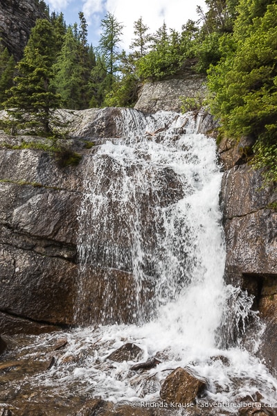
Near the end of Lake Agnes Trail, you‘ll come to a small waterfall then a staircase that leads up to the tea house on the shore of Lake Agnes.
.jpg)
If you want, you can buy a snack or a drink at the tea house before continuing on to the second section of the hike. While the views of Lake Agnes are beautiful, the crowds of people make it a lot less peaceful than it looks.
.jpg)
Part 2: Lake Agnes to Big Beehive (via Big Beehive Trail)
Part two of the hike to Devil’s Thumb is much more scenic than the first section, starting with an enjoyable walk along the shoreline to the far end of Lake Agnes. As you hike along Big Beehive Trail you get great views of the Devil’s Thumb and Mount Whyte.
.jpg)
.jpg)
At the end of the lake there are some large, flat-topped rocks to cross over then the well-worn trail makes its way across a scree-covered slope and into the trees.
.jpg)
Next comes a series of switchbacks that climb and weave among the trees, offering increasingly beautiful views of Lake Agnes the higher you get.
At the top of the switchbacks you’ll reach a flat area with a 4-way junction of trails. Going left will take you to Big Beehive, right leads to Devil’s Thumb, and straight goes down to the Highline Trail.
.jpg)
Big Beehive is really popular so if you visit it early (before Devil’s Thumb), there might be less people. However, if there’s a chance of rain in the afternoon, do the Devil’s Thumb route first because there’s a section that can be quite treacherous once it gets muddy.
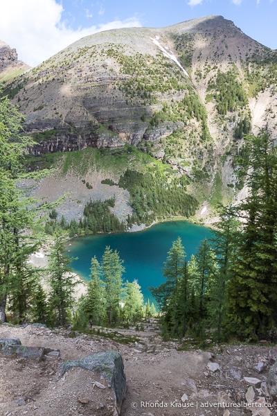
Heading left onto Big Beehive there’s not much change in elevation, just a few short ups and downs as you traverse over protruding rocks. Along the way there are openings in the trees where you can approach the cliff edge to see views of Lake Louise (just don’t get too close!)
.jpg)
.jpg)
At the end of the trail there is a covered shelter with a bench, but not much for views. The best scenery is definitely along the southern edge of Big Beehive.
After enjoying the milky green water of Lake Louise from above, head back to the trail intersection the same way you came. You’ll be able to see Devil’s Thumb, the next destination on this hike, off in the distance.
Part 3: Big Beehive to Devil’s Thumb (via Devil’s Thumb Trail)
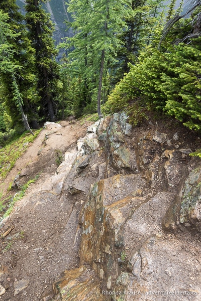
After arriving back at the trail junction from Big Beehive, you’ll want to continue straight onto the unmarked trail (at the time of this writing there was a tree fallen over the path). From this point, the Devil’s Thumb summit is slightly over 1 km away.
.jpg)
After a short distance walking on the treed path, the trail turns right and starts to go uphill. Soon you’ll come to a band of rock that needs to be climbed. It’s a very short, easy scramble and there’s no trouble finding sturdy handholds and places to step.
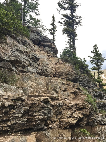
.jpg)
After the “light climbing”, the narrow trail proceeds along the side of a mountain to the backside of Devil’s Thumb. The trail is bordered by a wall of rock on one side and a valley on the other.
.jpg)
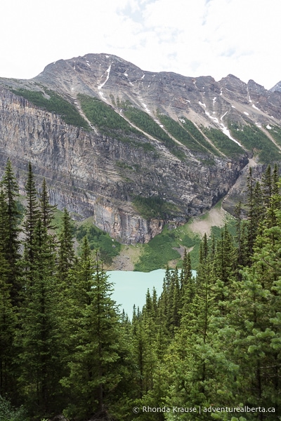
This part of the Devil’s Thumb hike is extremely scenic because there are fantastic views of the Plain of Six Glaciers including Mount Aberdeen and the Aberdeen Glacier, Mount Lefroy and the Lefroy Glacier, and Mount Victoria and the Victoria Glacier.
.jpg)
.jpg)
Unfortunately, most of the glaciers have retreated quite a bit and in the summer you see more of the moraine and sediment they’ve left behind than the glaciers themselves. Regardless, it’s still an impressive sight.
.jpg)
.jpg)
Once the trail reaches the end of the slope, it turns right and heads towards the most difficult part of the Devil’s Thumb hike.
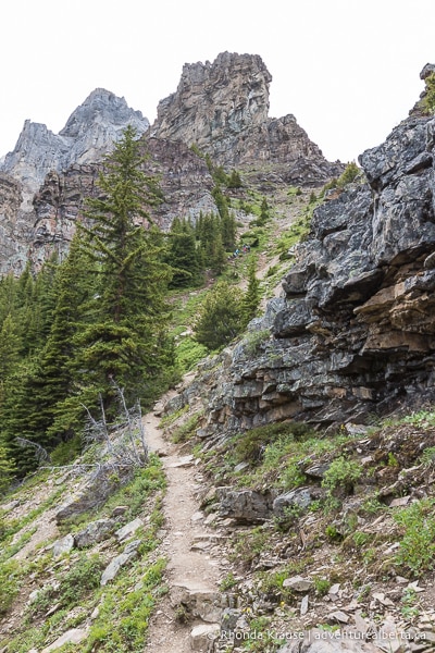
The final ascent up Devil’s Thumb is a steep one, with more exposure to the elements, and loose rock and soil making the terrain slippery in places. There are two possible routes you can take here- go straight up the middle of the gully or keep left closer to the trees.
.jpg)
Going straight is challenging because it’s all loose rock and dirt with nothing really to grasp onto if you start to slip. Keeping left is less rocky, with some trees and roots you can steady yourself with, but there’s more soil so it gets slick during/after the rain. Most people choose the left route.
.jpg)
A lot of trail reports on a popular app refer to this section of the Devil’s Thumb hike as a scramble, but that’s not quite accurate for two reasons- you don’t necessarily need to use your hands to pull yourself up or make headway (especially if you have hiking poles), and there’s a well-defined route to follow.
.jpg)
Nearing the top of the steep slope the terrain changes to rock, but there’s no climbing involved and it can easily be maneuvered on foot. However, the main trail does become somewhat lost in the rock, but you can still see several different trodden routes. Choose what you’re most comfortable with and keep going up.
.jpg)
.jpg)
.jpg)
Once you reach the top of the hill, keep walking straight to the end of Devil’s Thumb where the viewpoint is. Looking down from 2,459 m, you can see the Big Beehive nestled between Lake Agnes and Lake Louise, with the Little Beehive making an appearance in the background. It’s a marvelous view and perfect reward for the challenging hike up.
.jpg)
The panorama from Devil’s Thumb nicely summarizes this entire hike as you can see Chateau Lake Louise at the trailhead, Lake Agnes and its tea house, the switchbacks leading up to Big Beehive, and the entire shore of Lake Louise (which you’ll be hiking along later).
.jpg)
If the weather allows, this is a great place for a picnic. Just keep an eye out for an assertive chipmunk that begs for food and has no qualms about crawling into backpacks left on the ground.
Once you’re ready to begin your descent, retrace your steps on Devil’s Thumb Trail back to the intersection with Big Beehive Trail. This is where you’ll start the last segment of this hike.
.jpg)
Part 4: Devil’s Thumb Trailhead to Lake Louise (via the Highline Trail and Plain of Six Glaciers Trail)
To finish the loop, head downhill towards Lake Louise and the Plain of Six Glaciers on Big Beehive Trail (opposite the way you came up on).
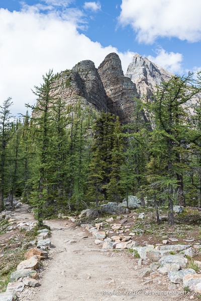
This forested path has some protruding rocks, longer switchbacks, and not much for views at first, but is enjoyable to walk because it’s the least frequented of all the sections of this Lake Louise hike.
.jpg)
.jpg)
When you reach the junction with the Highline Trail, you’ll want to go right towards the Plain of Six Glaciers. Turning left will take you back to Mirror Lake and Lake Agnes Trail.
Continuing down the Highline, the views open up and once again you can see the peaks that surround the Plain of Six Glaciers. Even from a lower elevation, it’s a beautiful scene.
.jpg)
.jpg)
At the next intersection, take the sharp left off the Highline onto the connector trail (keeping straight on the Highline will take you to the Plain of Six Glaciers Tea House, if you want to add more distance to your hike).
.jpg)
The connector trail continues to descend and has a short section of switchbacks before meeting up with the Plain of Six Glaciers Trail where you will go left. The sign here says it’s 4 km to the parking lot at Lake Louise.
.jpg)
.jpg)
.jpg)
Once you get on the Plain of Six Glaciers Trail it’s a simple walk back to Lake Louise. The path roughly follows along a creek before reaching the shore of Lake Louise. The final leg of the trail follows closely along the lakeshore, giving you one final opportunity to enjoy the turquoise waters of Lake Louise.
.jpg)
.jpg)
Your arrival at Chateau Lake Louise completes the Lake Agnes-Big Beehive-Devil’s Thumb loop and marks the end of one of the best hikes in Lake Louise!
Review of the Devil’s Thumb Hike
The Devil’s Thumb Hike via Lake Agnes and Big Beehive is a very rewarding way to experience the exquisite alpine scenery Lake Louise is known for.
.jpg)
The route has its challenges, but the views at the summit of Devil’s Thumb (and all other points of interest along the way) are the payoffs you’d expect for the effort invested. Being able to take in all of Lake Louise’s most famous landmarks from the trail makes the Devil’s Thumb hike a great way to make the most of a short visit.
.jpg)
The one downside is that the route is crowded at first, but gets less busy with each section of the hike. By the time you get on the Highline you’ll only occasionally see other hikers, since most people do an out-and-back instead of the longer loop.
Combining two established classics with an up-and-coming favourite makes this Lake Louise hike a must do!
.jpg)
Tips for Hiking Devil’s Thumb Trail
Location: Devil’s Thumb Trail is located at Lake Louise in Banff National Park.
Getting to the Devil’s Thumb Trailhead: After you reach the hamlet of Lake Louise via Highway 1 or Highway 93 (Icefields Parkway), drive uphill on Lake Louise Drive to the Chateau Lake Louise. The hiking trails start from the chateau.
- To reach the Devil’s Thumb Trailhead, you will have to hike there via the Lake Agnes Trail or the Plain of Six Glaciers Trail/Lake Louise Lakeshore Trail.
Best Time to Hike Devil’s Thumb: The Devil’s Thumb Hike is best done in July and August (summer in Banff National Park), but can be completed in late spring and early fall if clear of snow.
- Winter hiking is not recommended because of avalanche risk.
- Lake Louise is extremely popular and the parking lot does fill up in the summer months. Arriving early in the morning and/or on a weekday can help beat the crowds.
Facilities: There is a washroom building at the Lake Louise parking lot and an outhouse at the Lake Agnes Tea House. There are no garbage cans at the tea house so all garbage must be carried out.
Visitor Guidelines, Safety and Etiquette: Always hike within your limits and don’t get too close to cliff edges.
- Don’t attempt to hike Devil’s Thumb in poor weather, especially during or after the rain because the steep trail up the gully gets muddy and slippery.
- Devil’s Thumb Trail is exposed to the elements so dress for the weather and wear sun protection.
- This hike is in bear country so bring bear spray and know how to use it.
- This trail passes through avalanche zones. Avalanches can happen from November to June.
- Leave no trace by packing out all your garbage.
- Be considerate of other hikers by not eating your lunch in the best photo spot. Let everyone have a chance to get a picture of the two lakes below without strangers blocking the view.
Gear and What to Bring: Sturdy hiking shoes with ankle support are recommended because of the trail’s steep grade in places and rocky, uneven terrain. Hiking poles are also recommended to provide support going up and down the steep gully to the summit. Without them, you might have to “scramble” and use tree branches and roots for support.
- The weather can change quickly in the mountains so come prepared with layers and rain gear.
- Bring bug repellent, sunscreen, plenty of water, snacks, and a lunch to enjoy at the summit.
.jpg)
Accommodations in Lake Louise
For your convenience, here is a list of hotels in Lake Louise. Please consider booking your Lake Louise accommodations through the included link. It costs nothing extra and helps support this website. Thank you!
Nearby Hikes and Activities
You may also enjoy these other trails and things to do near Lake Louise village:
Shop for Devil’s Thumb Merchandise
.jpg)
.jpg)
.jpg)
.jpg)
.jpg)
.jpg)
Visit our store for more Alberta, nature, and adventure inspired products.


